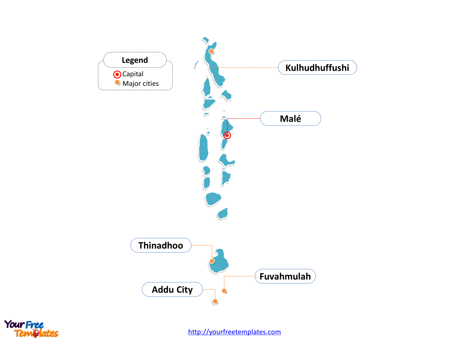
The Maldives Map Template in PowerPoint format includes three slides, that is, the Maldives outline ma, Maldives province map, and Maldives political map. Firstly, our Maldives outline map template has capital and major cities on it, which are Malé, Addu City, Fuvahmulah, Kulhudhuffushi, and Thinadhoo. Secondly, there are 7 provinces in our Maldives political map template, labeling the most populated divisions that are Mathi-Uthuru, Uthuru, Medhu-Uthuru, and Mathi-Dhekunu. Thirdly, there are 19 Atolls and 2 cities in the Maldives political map, labeling the major atolls of Haa Dhaalu, Raa, Haa Alif, and Kaafu.
Slide 1, Maldives map labeled with capital and major cities.
Our Maldives map is for the South Asian island country, located in the Indian Ocean, situated in the Arabian Sea. Maldives lies southwest of India, and Sri Lanka. Malé is the capital and largest city of Maldives, furthermore, other major cities including Addu City, Fuvahmulah, Kulhudhuffushi, and Thinadhoo. So our Maldives map slide has the capital and major cities on the outline map. Thus users can change cities to create their unique Maldives maps and apply in different presentations.

Slide 2, Maldives map labeled with major provinces.
The Maldives map is the country political division of 7 provinces from the source of Wikipedia. They are Mathi-Uthuru, Uthuru, Medhu-Uthuru, Medhu, Medhu-Dhekunu, Mathi-Dhekunu, and Dhekunu. Since every individual political province is an editable shape. As a result, you can change the texts, colors, sizes, highlight some provinces, and add your icons or charts.
At the same time you can also refer to the fully labeled Maldives map in Wikipedia. In a word, analysts from marketing research companies, advisors or consultants from professional firms have appreciated our map templates very much; because our maps can help them make their slides more professional and attractive.

Slide 3, Maldives map labeled with major Atolls and cities.
For the formal political subdivisions, Maldives is a country divided into 19 Atolls and 2 cities. The 19 atolls are Alif Alif, Alif Dhaal, Baa, Dhaalu, Faafu, Gaafu Alif, Gaafu Dhaalu, Gnaviyani, Haa Alif, Haa Dhaalu, Kaafu, Laamu, Lhaviyani, Meemu, Noonu, Raa, Shaviyani, Thaa, and Vaavu; and the 2 cities are Malé City and Addu City. Every individual atolls and cities is an editable shape. You can change the layout of the PowerPoint map, just keeping the shapes and highlighting your map shapes, and writing your content. Staff from traveling companies, managers from professional firms will find our slides can contribute to the success of their Maldives projects, because few sites in the web have this editable map available. Detailed and fully labeled map can be referred to Wikipedia Maldives.

Size:137K
Type: PPTX
Aspect Ratio: Standard 4:3
Click the blue button to download it.
Download the 4:3 Template
Aspect Ratio: Widescreen 16:9
Click the green button to download it.
Download the 16:9 Template


