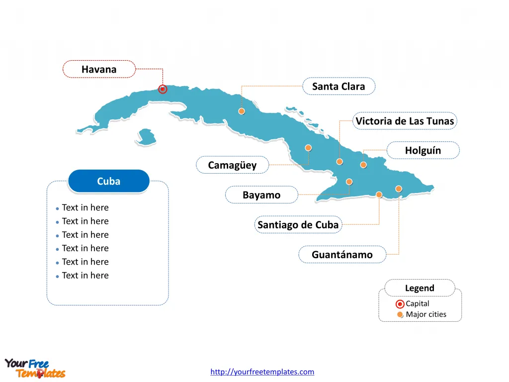
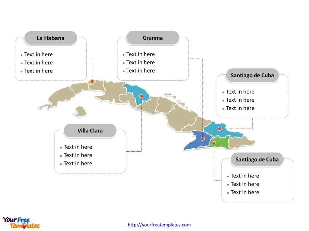
The Cuba Map Template includes two slides. Cuba map with 15 provinces and one special municipality, highlighting Granma, La Habana, Santiago de Cuba, and Villa Clara provinces. Cuba outline map labeled with Havana, Santiago de Cuba, Camagüey, Holguín, Santa Clara, Guantánamo, Bayamo, and Victoria de Las Tunas cities.
Cuba, located in the northern Caribbean where the Caribbean Sea, Gulf of Mexico, and Atlantic Ocean meet, is the largest island in the Caribbean. It shares maritime borders with the United States and the Bahamas. The country’s population, as of 2021, was estimated to be around 11.3 million people, with a diverse cultural heritage influenced by Spanish, African, and indigenous Taíno cultures.
Population and Economy
Cuba’s economy is characterized by state control and a socialist model, with key sectors including agriculture, tourism, and biotechnology. The country has faced economic challenges, but its government has been working to implement economic reforms to stimulate growth and attract foreign investment.
Neighboring Countries
Cuba’s closest neighbors are the United States, located to the north, and the Bahamas, to the northeast. These countries have had significant historical and political interactions with Cuba, shaping its development and international relations. You can find the 3 neighboring countries near with this country in the North America continent, which are Florida state of USA, the Bahamas, Haiti, and Jamaica.
Overall, Cuba’s unique location, population, and economic structure contribute to its distinct position in the Caribbean and global community.
Slide 1, Cuba map labeled with capital and major cities.
Its capital and largest city is Havana, other major cities including Santiago de Cuba, Camagüey, Holguín, Santa Clara, Guantánamo, Bayamo, and Victoria de Las Tunas.
Capital and major cities on Cuba map.
Havana: The Enchanting Capital
Havana, the pulsating heart of Cuba, is a captivating blend of old-world charm and contemporary vibrancy. Its well-preserved colonial architecture, lively music scene, and iconic Malecón promenade make it a must-visit destination. The city’s historic Old Havana district, a UNESCO World Heritage site, exudes timeless allure, while the bustling Vedado neighborhood offers a glimpse into Cuba’s modern urban life.
Santiago de Cuba: Cultural and Musical Heritage
Santiago de Cuba, the country’s second-largest city, is steeped in cultural and revolutionary history. Known as the “Cradle of the Revolution,” it boasts a vibrant Afro-Caribbean culture, lively music festivals, and the historic Moncada Barracks. The city’s lively Carnaval and the nearby El Cobre shrine add to its cultural significance.

Camagüey and Holguín: Architectural Splendor and Natural Beauty
Camagüey is renowned for its maze-like streets, well-preserved colonial architecture, and vibrant arts scene. In contrast, Holguín captivates with its natural beauty, including the stunning beaches of Guardalavaca and the picturesque countryside of Gibara.
Santa Clara and Guantánamo: Revolutionary History and Natural Wonders
Santa Clara holds a special place in Cuban history as the site of the decisive battle led by Che Guevara during the Cuban Revolution. Meanwhile, Guantánamo offers not only a complex geopolitical history but also breathtaking natural attractions, including the pristine Baracoa region and the Yunque de Baracoa, a distinctive table mountain.
Bayamo and Victoria de Las Tunas: Colonial Heritage and Cultural Charms
Bayamo, one of Cuba’s oldest cities, is steeped in colonial history and is known for its role in the struggle for independence. Victoria de Las Tunas offers a more relaxed pace, with its charming squares and vibrant cultural scene.
Slide 2, Cuba map labeled with major administration districts.
Cuba map is a country composed of 15 provinces and one special municipality, Artemisa, Camagüey, Ciego de Ávila, Cienfuegos, Granma, Guantánamo, Holguín, Isla de la Juventud, La Habana, Las Tunas, Matanzas, Mayabeque, Pinar del Río, Sancti Spíritus, Santiago de Cuba, and Villa Clara. Every individual political subdivision is an editable shape.
Major provinces highlighted on Cuba map.
Granma: Historic Significance and Natural Splendor
Granma province, named after the yacht that carried Fidel Castro and his revolutionaries to Cuba, is rich in history and natural beauty. From the historic landing site of the Granma yacht to the lush landscapes of the Sierra Maestra mountains, the province offers a compelling blend of history and nature.

La Habana: Cultural and Political Center
La Habana province, encompassing the capital city, is the political and cultural nucleus of Cuba. It is a vibrant hub of art, music, and history, and its surrounding beaches and countryside offer diverse recreational opportunities.
Santiago de Cuba: Where Culture Meets Nature
Santiago de Cuba province is a melting pot of Afro-Caribbean culture, revolutionary history, and natural wonders. The region’s diverse landscapes, including mountains, beaches, and forests, make it a captivating destination.
Villa Clara: Tranquility and History
Villa Clara province radiates tranquility and historical significance, with attractions such as the city of Santa Clara, the Che Guevara Mausoleum, and the stunning landscapes of the Escambray Mountains.
Cuba’s cities and provinces offer a tapestry of experiences, from historical and cultural immersion to natural exploration, making it a truly captivating destination for travelers seeking a unique and enriching experience.
Looking for Premium maps, please visit our affiliate site: https://editablemaps.com/ or https://ofomaps.com/
Size: 107K
Type: PPTX
Aspect Ratio: Standard 4:3
Click the blue button to download it.
Download the 4:3 Template
Aspect Ratio: Widescreen 16:9
Click the green button to download it.
Download the 16:9 Template


