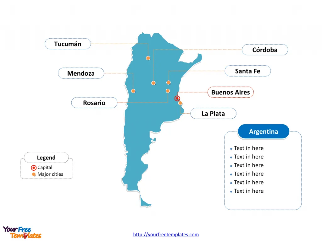
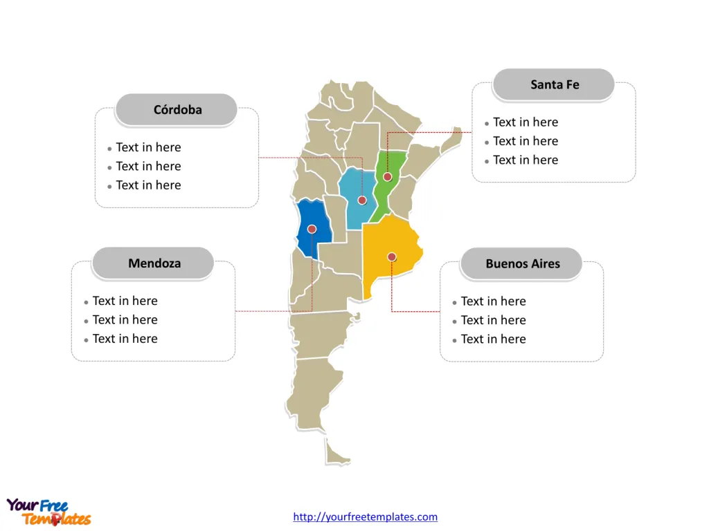
The Argentina Map Template includes two slides. Argentina map with 23 provinces and one autonomous city, highlighting Buenos Aires, Córdoba, Mendoza, and Santa Fe provinces. Argentina map labeled with Buenos Aires, Córdoba, Rosario, Mendoza, Tucumán, La Plata, and Santa Fe cities.
Argentina is located in the southern part of South America, extending from the tropics down to the sub-Antarctic regions, making it the eighth largest country in the world. It is positioned between the Andes mountain range to the west and the South Atlantic Ocean to the east and south.
Argentina shares its borders with five countries: to the north, it neighbors Bolivia and Paraguay; to the northeast, it adjoins Brazil; to the east, it is adjacent to Uruguay; and to the west, its border runs along Chile. This strategic location provides Argentina with a diverse ecosystem, ranging from rich plains to rugged mountains, and expansive coastlines.
Slide 1, Argentina map labeled with capital and major cities.
Argentina, a country of vast landscapes and vibrant cultural heritage, is defined not just by its diverse geography, but also by its dynamic cities and provinces. Among these, Buenos Aires, Córdoba, Rosario, Mendoza, Tucumán, La Plata, and Santa Fe stand out as significant urban centers, while the provinces of Buenos Aires, Córdoba, Mendoza, and Santa Fe play crucial roles in the nation’s economy and cultural identity.
Major Cities on Argentina map
Buenos Aires The capital city, Buenos Aires, is Argentina’s political, cultural, and economic heart. Known as the “Paris of South America,” it boasts a rich architectural and cultural heritage, with the Teatro Colón, a world-renowned opera house, and the historic quarter of San Telmo. Buenos Aires is a melting pot of European and Latin American influences, evident in its cuisine, fashion, and arts.
Córdoba Córdoba, the second-largest city, is an educational and commercial hub, home to the oldest university in the country, the National University of Córdoba. Known for its colonial architecture, the city also thrives on a vibrant contemporary arts scene. Córdoba’s economy is diversified, with strong sectors in manufacturing, technology, and agriculture.

Rosario Rosario, situated along the Paraná River, is a key agricultural and industrial center, renowned for its grain exports. The city is also famous for its neoclassical architecture, cultural festivals, and as the birthplace of iconic Argentine figures like Che Guevara and Lionel Messi. Rosario’s urban landscape is a blend of historic and modern, with numerous parks and museums enriching its cultural fabric.
Mendoza Mendoza is the heart of Argentina’s wine country, internationally recognized for producing some of the best Malbec wines. Nestled at the foothills of the Andes, its pleasant climate and scenic beauty make it a popular tourist destination. Mendoza’s economy is buoyed by viticulture, oil production, and tourism, contributing significantly to the national economy.
Tucumán San Miguel de Tucumán, often referred to simply as Tucumán, is known as the “Garden of the Republic” due to its lush landscapes. It’s a significant industrial and cultural center, with a rich history, notably as the site of the Declaration of Independence of Argentina in 1816. The city’s economy benefits from sugar production, textile, and automotive industries.
La Plata The city of La Plata, the capital of Buenos Aires Province, is distinguished by its unique urban planning and architecture, notably the neo-Gothic cathedral. Home to the National University of La Plata, the city is an important academic and research center. La Plata also enjoys a lively cultural scene, with theaters, museums, and galleries.
Santa Fe Santa Fe, located at the confluence of the Paraná and Salado rivers, is a crucial logistical and transportation hub. The city’s economy revolves around the commercial and service sectors, with a growing industrial presence. Santa Fe is known for its historical sites, colonial architecture, and vibrant cultural festivals.
Slide 2, Argentina map labeled with major administration districts.
Argentina is a country subdivided into twenty-three provinces and one autonomous city, Autonomous City of Buenos Aires, Buenos Aires Province, Catamarca, Chaco, Chubut, Córdoba, Corrientes, Entre Ríos, Formosa, Jujuy, La Pampa, La Rioja, Mendoza, Misiones, Neuquén, Río Negro, Salta, San Juan, San Luis, Santa Cruz, Santa Fe, Santiago del Estero, Tierra del Fuego, and Tucumán. Every individual political subdivision is an editable shape.
Major Provinces on Argentina map
Buenos Aires Province The province of Buenos Aires, surrounding the autonomous city, is Argentina’s most populous and economically significant region. Its vast agricultural lands make it a leading producer of beef, dairy, and grain, while the coastal city of Mar del Plata is a major tourist destination. The province also hosts a rich cultural life, with numerous sports and arts venues.

Córdoba Province Córdoba, with its diverse geography ranging from mountains to agricultural plains, is a key economic player. The province’s strong manufacturing sector, particularly in automotive and agricultural machinery, complements its agricultural produce. Córdoba is also a center for education and culture, with several universities and cultural institutions.
Mendoza Province Mendoza is synonymous with Argentina’s wine industry, with its favorable climate and geography contributing to the production of premium wines. The province’s economy is diversified, with significant contributions from tourism, especially adventure tourism and wine tours, and energy production, including hydroelectric and thermal power.
Santa Fe Province Santa Fe is an agricultural powerhouse, leading in the production of soybeans, corn, and sunflower. The province’s economy is also bolstered by a strong industrial sector, specializing in food processing, biofuels, and manufacturing. Santa Fe’s rich cultural heritage is celebrated through numerous festivals and events, reflecting the province’s historical significance and diverse communities.
Looking for Premium maps, please visit our affiliate site: https://editablemaps.com/ or https://ofomaps.com/
Size: 92K
Type: PPTX
Aspect Ratio: Standard 4:3
Click the blue button to download it.
Download the 4:3 Template
Aspect Ratio: Widescreen 16:9
Click the green button to download it.
Download the 16:9 Template


