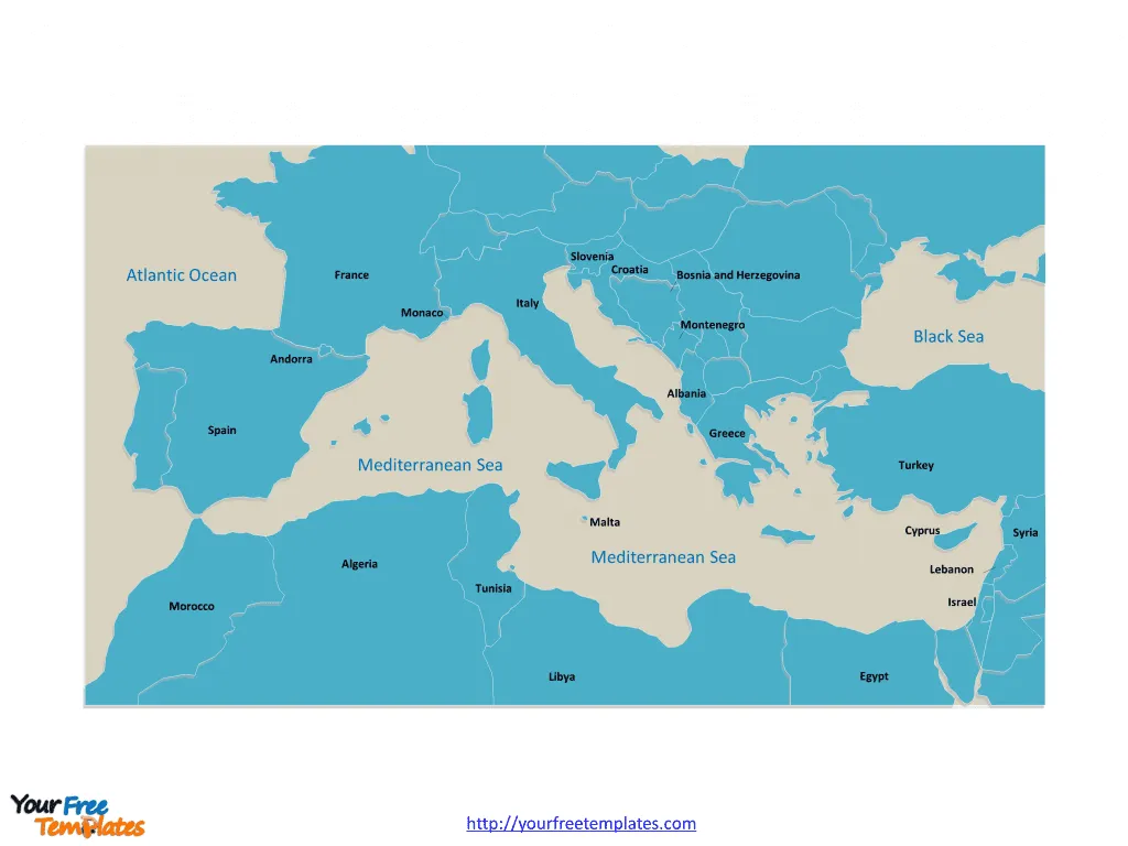
The Mediterranean Sea Map includes two slides. Mediterranean Sea map with 21 countries along the sea, there are 18 important cities along coastal.
Introduction to the Mediterranean Sea
As an avid traveler and explorer, I’ve always been fascinated by the allure of the Mediterranean Sea. This remarkable body of water, nestled between the continents of Europe, Asia, and Africa, has captivated the hearts and minds of people for millennia. From the ancient civilizations that flourished along its shores to the modern-day tourists who flock to its picturesque coastlines, the Mediterranean Sea has long been a hub of cultural, historical, and geographical significance.
In this comprehensive article, we’ll embark on a journey to unravel the mysteries of the Mediterranean, exploring its geography, the countries that border it, and the diverse cultures and cuisines that have been shaped by its influence. Whether you’re a seasoned traveler or someone who’s just beginning to discover the wonders of this region, this article will serve as your essential guide to navigating the Mediterranean Sea and its surrounding lands.
Geography and Size of the Mediterranean Sea
The Mediterranean Sea is a vast and expansive body of water, covering an area of approximately 2.5 million square kilometers (970,000 square miles). It is connected to the Atlantic Ocean through the Strait of Gibraltar, which separates the Iberian Peninsula from North Africa. The Mediterranean Sea is also connected to the Black Sea through the Bosporus Strait and the Sea of Marmara.
One of the defining features of the Mediterranean Sea is its relatively shallow depth, with an average depth of around 1,500 meters (4,900 feet). This shallow depth, combined with its unique geographic location, has contributed to the sea’s rich biodiversity and the development of diverse coastal ecosystems.
Importance of the Mediterranean Sea
The Mediterranean Sea has played a crucial role in shaping the history, culture, and economies of the regions that surround it. Throughout the centuries, it has served as a vital trade route, facilitating the exchange of goods, ideas, and people between the civilizations that have flourished along its shores.
The sea’s strategic location has also made it a hub of political and military significance, with numerous empires and nations vying for control over its waters and the territories that border it. From the ancient Greeks and Romans to the modern-day superpowers, the Mediterranean Sea has been a key battleground and a source of both conflict and cooperation.
In addition to its historical and geopolitical importance, the Mediterranean Sea is also a significant contributor to the global economy, supporting a thriving tourism industry, as well as a diverse range of maritime activities, such as fishing, shipping, and energy production.
Slide 1, Mediterranean Sea map labeled with country names.
Countries Bordering the Mediterranean Sea
The Mediterranean Sea is bordered by a total of 21 countries, each with its own unique cultural, historical, and geographical characteristics. These countries can be divided into four main regions: Northern Mediterranean, Eastern Mediterranean, Southern Mediterranean, and Western Mediterranean.
Northern Mediterranean Countries
Eastern Mediterranean Countries
Southern Mediterranean Countries
Western Mediterranean Countries
Slide 2, Mediterranean Sea map labeled with important capitals and cities.
Map of the Mediterranean Sea
To provide a visual representation of the countries surrounding the Mediterranean Sea, here is a comprehensive map:
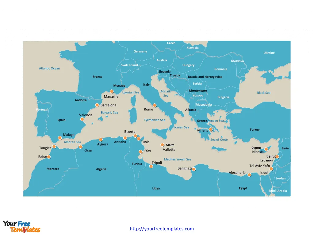
This map illustrates the geographic distribution of the countries that make up the Mediterranean region, allowing you to better understand the relative positions and proximity of these nations to the sea.
Lesser-Known Mediterranean Islands
While the major countries bordering the Mediterranean Sea are well-known, there are also a number of lesser-known islands that are part of this vast and diverse region. These islands, scattered throughout the sea, offer unique cultural experiences and breathtaking natural landscapes for adventurous travelers.
Some of the lesser-known Mediterranean islands include:
- Gozo (Malta)
- Pantelleria (Italy)
- Lampedusa (Italy)
- Corsica (France)
- Balearic Islands (Spain)
- Cyclades Islands (Greece)
- Dodecanese Islands (Greece)
- Maltese Archipelago (Malta)
- Lipari Islands (Italy)
Exploring these hidden gems can provide a more immersive and authentic experience of the Mediterranean, away from the crowds and the well-trodden tourist paths.
Popular Tourist Destinations in the Mediterranean
The Mediterranean Sea is renowned for its stunning coastal cities, picturesque islands, and rich cultural heritage, making it a premier destination for travelers from around the world. Some of the most popular tourist destinations in the Mediterranean include:
- Barcelona, Spain: Known for its vibrant architecture, lively street life, and world-class cuisine.
- Amalfi Coast, Italy: A breathtaking stretch of coastline with charming seaside towns and stunning natural beauty.
- Santorini, Greece: A picturesque island with whitewashed buildings, stunning sunsets, and stunning caldera views.
- Dubrovnik, Croatia: A UNESCO World Heritage Site with well-preserved medieval walls and a charming old town.
- Marrakech, Morocco: A vibrant and culturally-rich city known for its bustling markets, historic landmarks, and unique architecture.
- Istanbul, Turkey: A city that straddles the line between Europe and Asia, offering a rich blend of cultures, history, and modern amenities.
- Valletta, Malta: The capital of Malta, known for its impressive fortifications, baroque architecture, and stunning coastal views.
These are just a few of the many captivating destinations that draw millions of visitors to the Mediterranean each year, enticing them with the region’s unparalleled natural beauty, cultural heritage, and diverse experiences.
Exploring the Mediterranean Cuisine and Culture
One of the most rewarding aspects of exploring the Mediterranean is the opportunity to immerse oneself in the region’s rich culinary and cultural traditions. From the sun-drenched vineyards of Italy to the fragrant spice markets of Morocco, the Mediterranean offers a tantalizing array of flavors and experiences that reflect the diversity of the countries and cultures that surround the sea.
The Mediterranean diet, renowned for its health benefits and delicious flavors, is a testament to the region’s agricultural bounty and culinary ingenuity. Dishes such as pizza, pasta, paella, moussaka, and tagine have become beloved worldwide, but experiencing them in their authentic, local contexts can be a truly transformative experience.
Beyond the food, the Mediterranean is also home to a vibrant cultural tapestry, with each country and region boasting its own unique traditions, art, music, and architectural styles. From the ancient ruins of Greece and Rome to the intricate tile work of Andalusia, the Mediterranean is a treasure trove of cultural riches waiting to be discovered.
Looking for Premium maps, please visit our affiliate site: https://editablemaps.com/ or https://ofomaps.com/
Size:232K
Type: PPTX
Aspect Ratio: Standard 4:3
Click the blue button to download it.
Download the 4:3 Template
Aspect Ratio: Widescreen 16:9
Click the green button to download it.
Download the 16:9 Template
