The Pacific Ocean Map Template includes three slides. Pacific Ocean map labeling 17 major countries, including Russia, Japan, South Korea, China, Philippines, Malaysia, Indonesia, Australia, New Zealand, Papua New Guinea, Canada, United States, Mexico, Colombia, Ecuador, Peru, and Chile. There are 18 important cities along the Pacific Rim on Pacific Ocean map. You can check our Atlantic Ocean, Indian Ocean, Red Sea, Black Sea, Mediterranean Sea, and Caribbean Sea map templates.
The Pacific Ocean, the largest and deepest of Earth’s oceanic divisions, touches the shores of multiple continents, hosts numerous countries, and is rimmed by key cities that play significant roles in global culture, economy, and geopolitics. Spanning from the Arctic in the north to the Southern Ocean in the south, its vast expanse connects the Americas to Asia and Oceania.
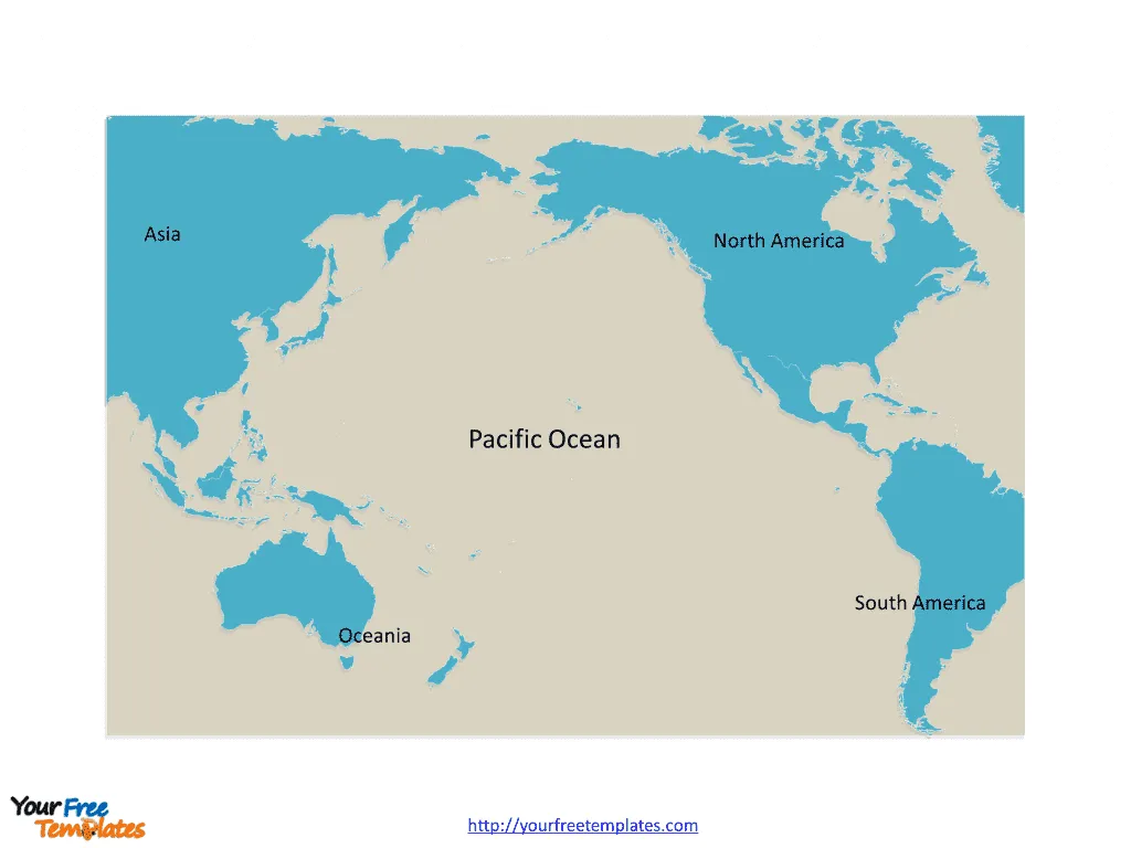
Slide 1, Pacific Ocean map labeled with continent names.
The Pacific Ocean is the largest and deepest of the Earth’s oceanic divisions. It extends from the Arctic Ocean in the north to the Southern Ocean in the south and is bounded by Asia and Australia in the west and the Americas in the east.
Asia
Asia, with its extensive Pacific coastline, includes countries like China, Japan, South Korea, and the Philippines, each contributing rich cultural heritage and economic prowess.
North America
North America’s Pacific coast features the United States and Canada, countries known for their significant contributions to technology, entertainment, and trade.
South America
The western coast of South America, with countries such as Chile and Peru, offers diverse ecosystems ranging from arid deserts to fertile vineyards.
Oceania
Oceania encompasses Australia, New Zealand, and numerous Pacific island nations, each boasting unique cultures, breathtaking landscapes, and vibrant marine life.

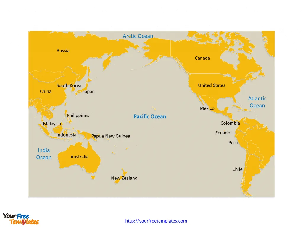
Slide 2, Pacific Ocean map labeled with major country names.
There are 17 major countries along the Pacific Rim; they are Russia, Japan, South Korea, China, Philippines, Malaysia, Indonesia, Australia, New Zealand, Papua New Guinea, Canada, United States, Mexico, Colombia, Ecuador, Peru, and Chile. Every individual political subdivision is an editable shape.
Major Countries and Important Cities on Pacific Ocean Map
- United States
- Los Angeles, California, a global entertainment hub.
- San Francisco, California, known for its tech innovation and iconic Golden Gate Bridge.
- Seattle, Washington, famous for its coffee culture and tech industry.
- Canada
- Vancouver, British Columbia, a city known for its natural beauty and diverse population.
- China
- Shanghai, a bustling metropolis blending tradition and modernity.
- Beijing, the capital city with historical sites like the Forbidden City.
- Japan
- Tokyo, a city that epitomizes cutting-edge technology alongside traditional culture.
- Osaka, known for its culinary scene and lively atmosphere.

- Australia
- Sydney, with its iconic Opera House and Harbour Bridge.
- Melbourne, a cultural capital famous for its art and coffee culture.
- New Zealand
- Auckland, a major city known for its harbors and multicultural vibe.
- Chile
- Santiago, nestled by the Andes, a center of culture and politics.
- Peru
- Lima, a city rich in colonial history and gastronomy.
The Pacific Ocean, with its wide breadth, touches lands that vary dramatically in their natural landscapes, cultures, and economies. Cities along the Pacific Rim are often gateways to exploring the rich diversity that characterizes the regions of this vast oceanic expanse. From the tech hubs of Silicon Valley to the historic streets of Lima, the Pacific Rim offers a kaleidoscope of experiences for travelers, businesses, and locals alike.
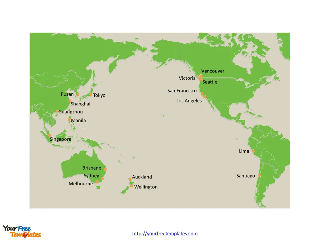
Slide 3, Pacific Ocean map labeled with major cities.
There are 18 important cities from major countries along the Pacific Rim; they are Vancouver, Victoria, Seattle, San Francisco, Los Angeles, Lima, Santiago, Auckland, Wellington, Brisbane, Sydney, Melbourne, Singapore, Manila, Guangzhou, Shanghai, Tokyo, and Pusan.

Looking for Premium maps, please visit our affiliate site: https://ofomaps.com/
Size:371K
Type: PPTX
Aspect Ratio: Standard 4:3
Click the blue button to download it.
Download the 4:3 Template
Aspect Ratio: Widescreen 16:9
Click the green button to download it.
Download the 16:9 Template


