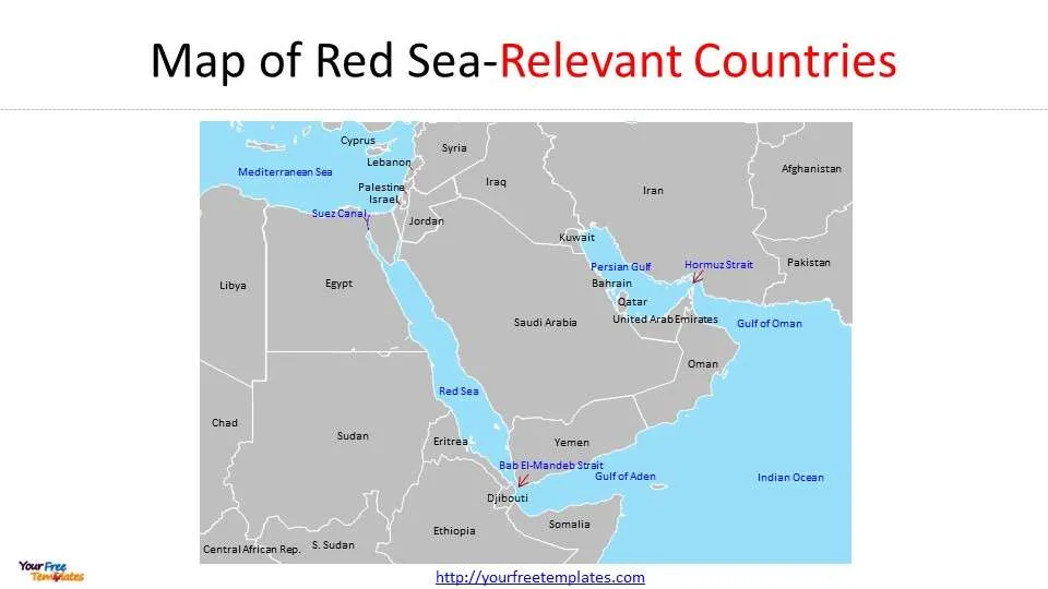
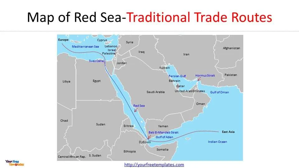
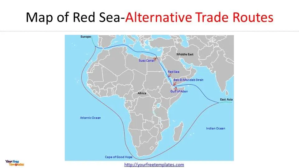
The Red Sea Map template in PowerPoint format includes 3 slides. Firstly, we have the common Red Sea map. Secondly, we present the map of Red Sea with traditional trade routes. Thirdly the map of Red Sea with alternative trade routes under the circumstances of latest merchant shipping attacks originated from Israeli-Palestinian conflict. As the same diagram PowerPoint template series, you can also find our Carbon footprint, Carbon neutral, Data Mining, Machine Learning, cloud computing, Artificial Intelligence and BlockChain or Central Europe, Eastern Europe, Israel Palestine map PowerPoint templates.
History of the Red Sea map and its Significance in World History
The Red Sea has played a significant role in world history, primarily due to its strategic location. It has been a hub for international trade for centuries, serving as a critical route connecting the Mediterranean Sea to the Indian Ocean. Ancient civilizations, including those of Egypt, Rome, and Greece, heavily relied on the Red Sea for commerce and transportation.
In the Middle Ages, the Red Sea gained even more prominence as the primary route for the spice trade between Europe and Asia. It was not just the wealth of goods that passed through these waters that made the Red Sea so vital, but also its role in religious pilgrimages. For Muslims, the Red Sea was the gateway to Mecca, the holiest city in Islam, making it a heavily traversed stretch of water throughout history. Countries bordering the red sea are Saudi Arabia, Sudan, Egypt, Eritrea, Yemen, and Djibouti.

Red Sea: A Detailed Look
A detailed look at the red sea map reveals why it is a prime location for pirate attacks. The shape and geographical features of the Red Sea make it a favorable environment for pirates. It’s a long and narrow sea, which allows pirates to trap their targets easily. The numerous small islands and coves provide ideal hiding spots for pirate ships, making it difficult for merchant vessels to foresee an attack.
A review of historical pirate attacks in the Red Sea reveals a pattern. Most attacks have taken place in the southern Red Sea, where the sea is at its narrowest. The Bab el Mandeb Strait, in particular, has been a hotspot for pirate attacks due to its strategic location and narrow passage.
Notorious Pirate Attacks in the Red Sea: Locations and Impacts
Studying the red sea map, one can pinpoint several locations where notorious pirate attacks have taken place. For instance, the Bab el Mandeb Strait, a critical chokepoint connecting the Red Sea to the Gulf of Aden, has seen a significant number of attacks.
The impact of these pirate attacks has been profound. They have disrupted trade routes, caused economic losses, and led to a climate of fear and insecurity. The attacks have also had a significant impact on the shipping industry, leading to increased insurance costs and heightened security measures.
The latest Red Sea attack was carried out by Yemen’s Houthi movement, which has been targeting commercial traffic in the region. In response, the United States has assembled a multinational naval coalition to safeguard commercial traffic from these attacks. More than 20 countries, including the US, UK, and France, have joined this coalition, known as Operation Prosperity Guardian. The coalition involves joint patrols in Red Sea waters near Yemen. The attacks by the Houthis have disrupted trade routes and caused shipping costs to rise. The US and its partners are committed to protecting ships from further attacks.
Red Sea Map with Trade Routes Impacted by Pirate Attacks
Pirate attacks in the Red Sea have had a significant impact on trade routes. With the Red Sea serving as a conduit for a large volume of the world’s maritime trade, disruptions caused by pirate attacks have had far-reaching consequences.
For instance, the Suez Canal, a man-made waterway connecting the Red Sea to the Mediterranean Sea, is one of the world’s busiest shipping lanes. Pirate attacks in the Red Sea often lead to delays and rerouting of ships, causing significant economic losses.

The Red Sea on the World Map: Understanding its Strategic Position
When one looks at the Red Sea on the world map, its strategic importance becomes evident. It lies at the crossroads of Asia, Africa, and Europe, making it a crucial link in global trade.
Moreover, the Red Sea is home to the Suez Canal, one of the world’s most important waterways. This canal not only connects the Red Sea to the Mediterranean but also provides the shortest maritime route between Europe and Asia. Hence, any disruption in the Red Sea, such as pirate attacks, can have a global impact.
The trade routes impacted by the latest Red Sea pirate attacks include the Asia-Europe trade route and the Suez Canal. Major shipping companies and oil giants have suspended their operations in the Red Sea due to recent attacks by Iran-backed Yemen’s Houthi rebels. As a result, companies are rerouting their ships away from the Suez Canal and the Bab al-Mandab chokepoint, particularly those with Israeli links. Asian exporters are also expected to be negatively impacted as more shipping companies choose to avoid the Red Sea and sail around Africa instead. These disruptions to trade routes could cause delays and increased shipping costs, affecting the global economy and potentially pushing inflation up.

Impact of Pirate Attacks on Red Sea’s Marine and Tourism Industries
Pirate attacks in the Red Sea have not only disrupted trade but also adversely affected the region’s marine and tourism industries. The constant threat of piracy has deterred tourists, leading to a decline in tourist arrivals.
Moreover, pirate attacks have led to an increase in maritime pollution. Often, pirates damage or sink ships, leading to oil spills and other forms of pollution that harm the Red Sea’s marine biodiversity.
Conclusion: Navigating the Red Sea Safely
In conclusion, navigating the Red Sea, given its historical and ongoing issues with piracy, requires vigilance and strategic planning. Understanding the red sea map and its history can provide critical insights into potential danger zones and help in devising effective safety measures. It is only through a combination of individual responsibility, technological advancements, and international cooperation that the Red Sea can once again be a safe passage for all.
For other interesting maps, pls visit our ofomaps.com
Size:710K
Type: PPTX
Aspect Ratio: Standard 4:3
Click the blue button to download the maps.
Download the 4:3 Template
Aspect Ratio: Widescreen 16:9
Click the green button to download the maps.
Download the 16:9 Template


