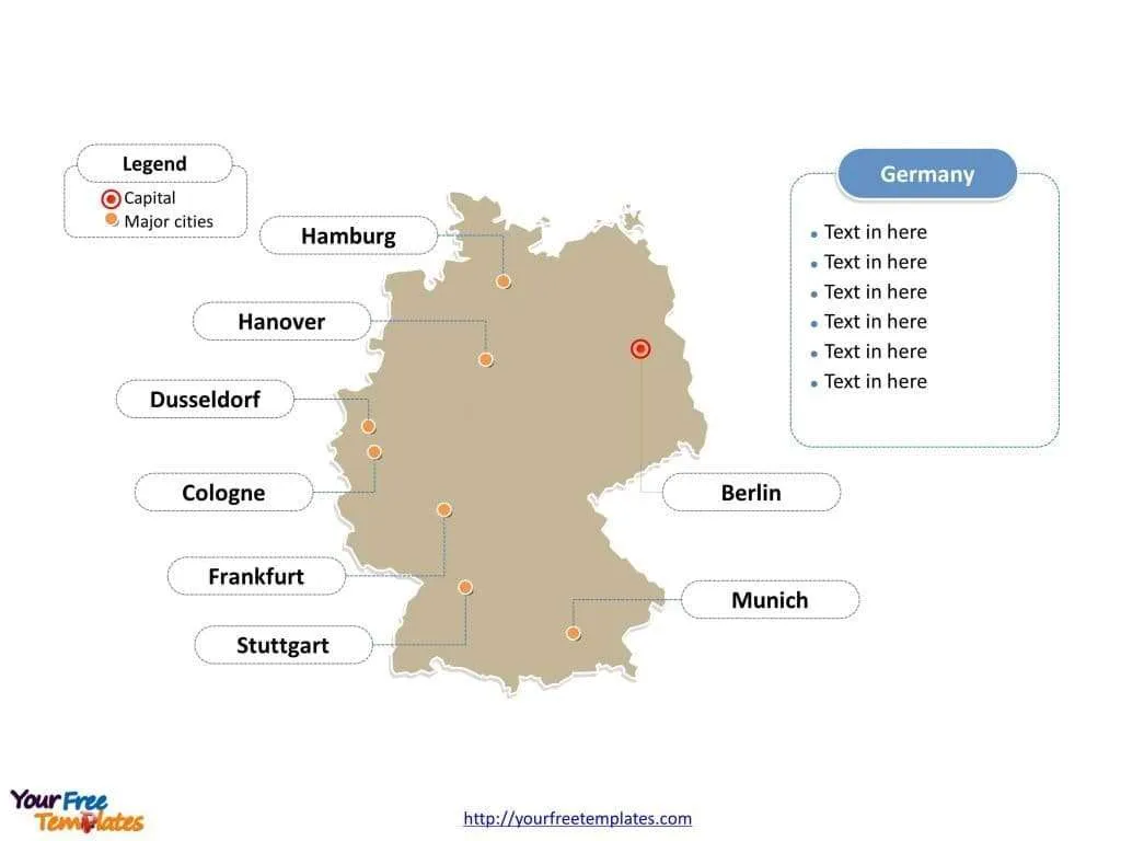
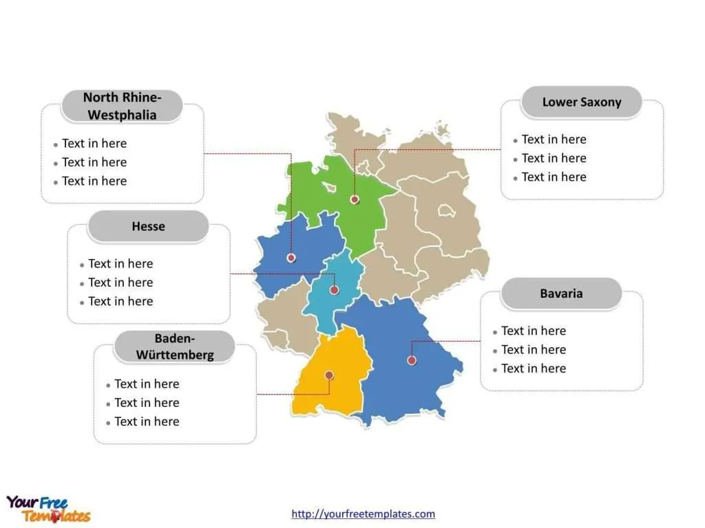
Germany map with 16 states, highlighting Baden-Württemberg, Bavaria, Hesse, Lower Saxony, and North Rhine-Westphalia states. Germany outline map labeled with Berlin, Hamburg, Munich, Cologne, Frankfurt, Stuttgart, and Düsseldorf cities.
Germany, a country in the heart of Europe, is known for its rich history, culture, and economic prowess. It has a federal structure composed of sixteen states (Bundesländer), each with its own constitution, legislature, and government. Among these states are vibrant cities that play a significant role in the economic, cultural, and political life of the country.
Slide 1, Germany map labeled with capital and major cities.
Germany is covering 357,021 square kilometres with about 81.8 million inhabitants. Its capital and largest city is Berlin, other major cities including Hamburg, Munich, Cologne, Frankfurt, Stuttgart, and Düsseldorf.
Germany’s Capital, Major Cities on our Germany Map
Berlin – The Capital City
Berlin, the capital of Germany, is a city steeped in history and a symbol of reunification. It is known for its vibrant art scene, nightlife, and landmarks such as the Brandenburg Gate, the Berlin Wall remnants, and the Reichstag building. As a hub of politics and culture, Berlin hosts numerous festivals, museums, and historical sites.
Hamburg
Germany’s second-largest city and a major port, Hamburg, is known for its maritime heritage, which is celebrated in the historic Speicherstadt warehouse district and the modern HafenCity. Its waterways and canals earned it the nickname “Venice of the North.”
Munich
The capital of Bavaria, Munich, is famed for its beautiful architecture, fine culture, and the annual Oktoberfest beer celebration. The city has a high quality of life and is the gateway to the Alps.
Cologne
Cologne is recognized for its impressive Gothic cathedral, Kölner Dom. It is a significant cultural center for the Rhineland with numerous galleries, museums, and the famous Cologne Carnival.

Frankfurt
Known as the financial capital of Germany, Frankfurt is the home of the European Central Bank and the German Stock Exchange. Its skyline, dotted with skyscrapers, has earned it the nickname “Mainhattan.”
Stuttgart
As the capital of Baden-Württemberg, Stuttgart is known for its automotive industry, being the headquarters of Mercedes-Benz and Porsche. It is also recognized for its green spaces, such as the Schlossgarten.
Düsseldorf
The capital city of North Rhine-Westphalia, Düsseldorf, is an international business and financial center. Famous for its fashion industry and art scene, it also hosts the annual Rhenish Carnival celebrations.
Germany’s cities reflect the country’s pivotal role in European history and its position at the forefront of contemporary economic, cultural, and political developments. Berlin stands as a vibrant center of change and innovation, while cities like Hamburg and Munich display a blend of traditional and modern influences. The industrial and financial might of cities such as Frankfurt and Düsseldorf represents Germany’s economic strength.
Slide 2, Germany map labeled with major States.
Germany is a country composed of 16 states, Baden-Württemberg, Bavaria, Berlin, Brandenburg, Bremen, Hamburg, Hesse, Mecklenburg-Vorpommern, Lower Saxony, North Rhine-Westphalia, Rhineland-Palatinate, Saarland, Saxony, Saxony-Anhalt, Schleswig-Holstein, and Thuringia. Every individual political subdivision is an editable shape. You can refer to detailed political division map of Germany in Wikipedia.
Major States on our Germany Map
Baden-Württemberg
Baden-Württemberg is a state in the southwest of Germany known for its innovation and high standard of living. Home to the Black Forest and the cities of Stuttgart and Heidelberg, the state is a leader in technology and engineering.
Bavaria (Bayern)
Bavaria is the largest state by land area and is famous for its unique cultural identity, including traditions such as lederhosen and dirndls, beer, and the Bavarian Alps. Its capital, Munich, is a cultural and economic powerhouse.
Hesse (Hessen)
Hesse is situated in central Germany, with Frankfurt am Main as its largest city and economic center. The state is known for its picturesque towns, such as Wiesbaden and Darmstadt, and the Taunus mountain range.
Lower Saxony (Niedersachsen)
Lower Saxony is a state in the northwest of Germany, bordering the North Sea. It is the second-largest state by land area and offers diverse landscapes from the Harz mountains to the heathland. The state capital is Hanover, a major exhibition center.
North Rhine-Westphalia (Nordrhein-Westfalen)
North Rhine-Westphalia is the most populous state and a key economic region. It includes the Ruhr industrial area and cities such as Cologne, Düsseldorf, and Dortmund. The state is also known for its cultural institutions and industrial heritage.

The German states each have their distinct charm and contribute significantly to the nation’s identity. From the engineering feats of Baden-Württemberg to the financial hubs in Hesse, the cultural richness of Bavaria to the natural beauty of Lower Saxony, and the industrial heartland of North Rhine-Westphalia, Germany offers a diverse array of experiences. This blend of regional characteristics and local traditions within a framework of unity is what makes Germany a fascinating country to explore and understand.
Size: 104K
Type: PPTX
Aspect Ratio: Standard 4:3
Click the blue button to download it.
Download the 4:3 Template
Aspect Ratio: Widescreen 16:9
Click the green button to download it.
Download the 16:9 Template


