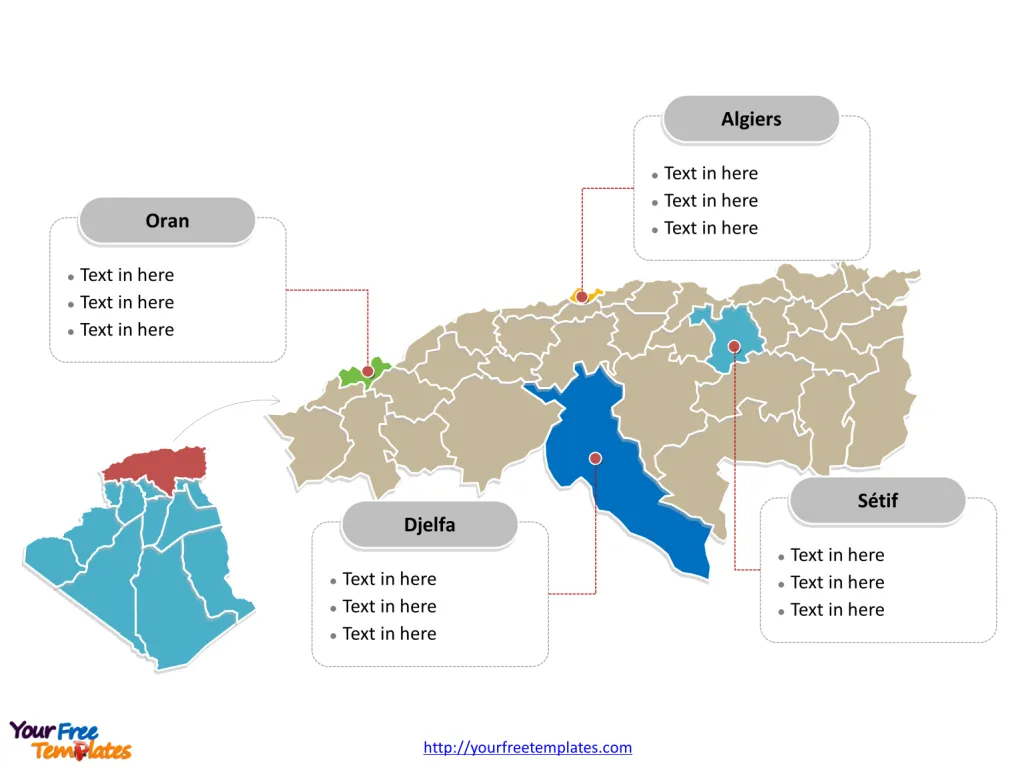
The Algeria Map Template includes three slides. Algeria map with 48 provinces, labeling with major provinces, Algiers, Oran, Sétif, and Djelfa. Algeria map labeling with national capital and major cities, Algiers, Oran, Constantine, Annaba, and Batna.
Algeria, a North African country, is the largest country on the continent and is bordered by the Mediterranean Sea to the north, Tunisia and Libya to the northeast, Niger to the southeast, Mali and Mauritania to the southwest, Western Sahara to the west, and Morocco to the northwest. With a population of over 44 million, it is known for its rich history, diverse culture, and Sahara desert.
The Algerian economy is heavily reliant on hydrocarbons, with oil and natural gas exports being the backbone of the country’s economy. Additionally, agriculture and mining also contribute significantly to the nation’s economic output. Algeria has been making efforts to diversify its economy by investing in renewable energy and other non-oil sectors.
Slide 1, Algeria map labeled with capital and major cities.
Algeria is a country in the Maghreb region of Africa, with Algiers as its capital and most populous city, other major cities including Oran, Constantine, Annaba, and Batna.
Capital and Major Cities on Algeria map
Algiers
Algiers, the capital of Algeria, is a bustling coastal city with a rich historical heritage. It serves as a significant economic and cultural center, offering a blend of modernity and traditional charm. Notable landmarks include the historic Casbah and the modern Algiers Marina.

Oran
Oran, the country’s second-largest city, is a major port and industrial center. Known for its vibrant arts scene and historical sites, it plays a pivotal role in Algeria’s economic and cultural landscape.
Constantine
Constantine, often referred to as the “City of Bridges,” is famed for its dramatic setting atop a plateau, with numerous bridges spanning deep gorges. It is a major cultural and educational hub, hosting several universities and historical marvels.
Annaba
Annaba, situated on the northeastern coast, is a prominent industrial and commercial city. It boasts a rich history dating back to Phoenician times and offers a picturesque Mediterranean coastline.
Batna
Batna, located in the Aures Mountains, is known for its captivating natural beauty and historical significance. It is a key urban center with a focus on agriculture, commerce, and tourism.
Slide 2, Algeria map labeled with major administration districts.
Algeria is a country with 48 provinces (wilayas); they are Adrar, Ain Defla, Ain Timouchent, Algiers, Annaba, Batna, Béchar, Béjaïa, Biskra, Blida, Bordj Bou Arréridj, Bouïra, Boumerdes, Chlef, Constantine, Djelfa, El Bayadh, El Oued, El Taref, Ghardaia, Guelma, Illizi, Jijel, Khenchela, Laghouat, Mascara, Médéa, Mila, Mostaganem, M’Sila, Naâma, Oran, Ouargla, Oum El Bouaghi, Relizane, Saïda, Sétif, Sidi Bel Abbès, Skikda, Souk Ahras, Tamanrasset, Tébessa, Tiaret, Tindouf, Tipaza, Tissemsilt, Tizi Ouzou, and Tlemcen. Every individual political subdivision is an editable shape.
Major Provinces on Algeria map
Algiers
The Algiers Province, with the city of Algiers as its capital, is a vital administrative, economic, and cultural region. It serves as the nucleus of political, commercial, and cultural activities, shaping the country’s urban and rural landscape.

Oran
The Oran Province, with the city of Oran, is an essential area known for its industrial and commercial significance, contributing significantly to Algeria’s economy and urban development.
Sétif
The Sétif Province, with the city of Sétif, is a significant region known for its educational and historical prominence. It plays a crucial role in shaping Algeria’s academic and cultural landscape.
Djelfa
The Djelfa Province, with the city of Djelfa, is a crucial region known for its agricultural significance and historical heritage, influencing the country’s economic and social development.
Slide 3, Algeria map highlighted with northern provinces.

In summary, Algeria’s capital, major cities, and provinces each contribute uniquely to the country’s economic, cultural, and urban development, offering a rich blend of experiences that reflect its historical roots while embracing the future.
Looking for Premium maps, please visit our affiliate site: https://editablemaps.com/ or https://ofomaps.com/
Size: 242K
Type: PPTX
Aspect Ratio: Standard 4:3
Click the blue button to download it.
Download the 4:3 Template
Aspect Ratio: Widescreen 16:9
Click the green button to download it.
Download the 16:9 Template


