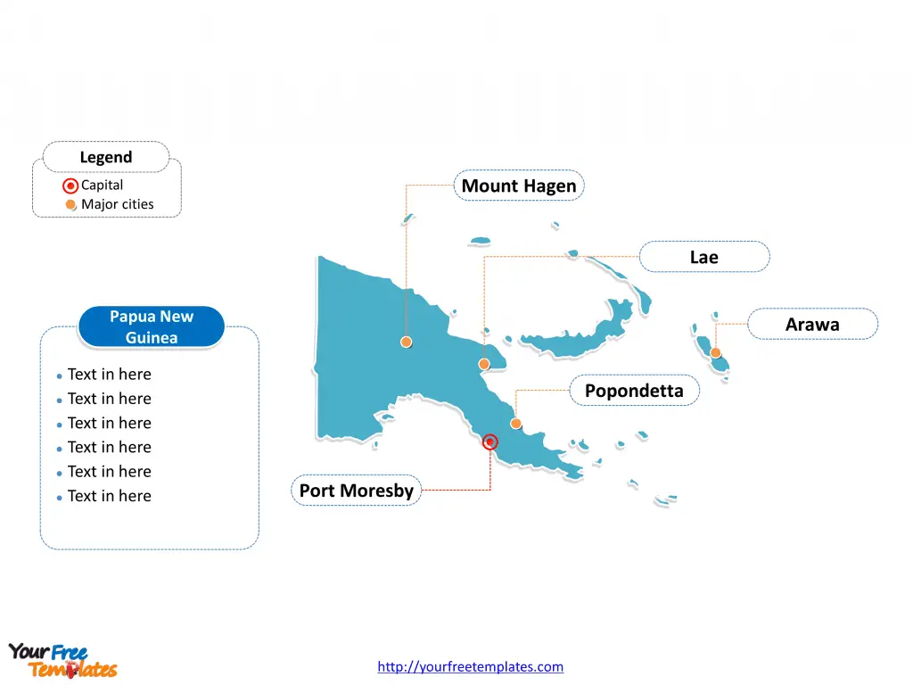
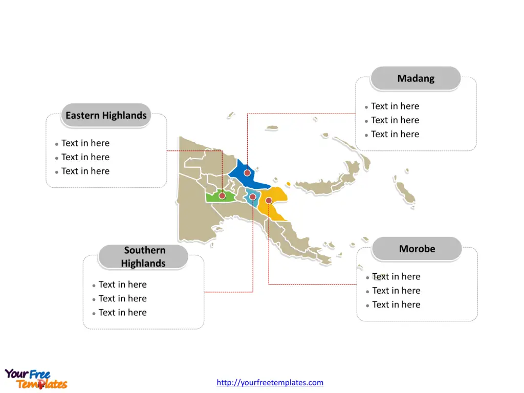
The Papua New Guinea Map Template includes two slides. Papua New Guinea map with twenty provinces, the Autonomous Region of Bougainville and the National Capital District, highlighting main regions, Morobe, Eastern Highlands, Southern Highlands, and Madang. Papua New Guinea map labeled with capital and major cities, Port Moresby, Lae, Arawa, Mount Hagen, and Popondetta.
Introduction to Papua New Guinea
Papua New Guinea is a captivating and enigmatic country that has long captured the imagination of travelers and adventurers alike. Nestled in the heart of the South Pacific, this diverse and vibrant nation is a true gem waiting to be discovered. From its towering mountain ranges to its pristine tropical forests, Papua New Guinea offers a wealth of natural wonders that are sure to leave a lasting impression on all who visit.
In this article, we’ll embark on a journey to explore the beauty of Papua New Guinea through the lens of its captivating map. We’ll delve into the country’s rich geography, uncover the secrets of its diverse regions, and discover the best ways to utilize digital resources to plan your own unforgettable adventure.
Slide 1, Papua New Guinea map labeled with capital and major cities.
Overview of Papua New Guinea’s Geography
Papua New Guinea is a land of striking contrasts, boasting a diverse array of landscapes and ecosystems that are truly awe-inspiring. Situated on the eastern half of the island of New Guinea of Oceania, the country is characterized by its rugged terrain, with towering mountain ranges, deep valleys, and lush tropical forests.
One of the most striking features of Papua New Guinea’s geography is its extensive network of rivers and waterways. The Fly River, the country’s longest and most important river, winds its way through the heart of the country, providing a vital transportation route and supporting a rich diversity of aquatic life.
The country’s coastline is equally impressive, with pristine beaches, mangrove swamps, and vibrant coral reefs that teem with marine life. From the bustling port city of Lae to the remote and untouched islands of the Bismarck Archipelago, Papua New Guinea’s coastal regions offer a wealth of opportunities for exploration and discovery.
Exploring the Capital and Major Cities of Papua New Guinea Through its Map
Its capital and largest city is Port Moresby, other major cities including Lae, Arawa, Mount Hagen, and Popondetta. At the heart of Papua New Guinea’s map lies the capital city of Port Moresby, a bustling and cosmopolitan hub that serves as the country’s political and economic center. As you explore the map, you’ll discover that Port Moresby is home to a diverse array of attractions, from the iconic Ela Beach to the National Parliament House, which features stunning architecture and artwork that celebrates the country’s rich cultural heritage.

Beyond Port Moresby, Papua New Guinea’s map reveals a tapestry of other major cities and urban centers, each with its own unique character and charm. In the northern region, the city of Lae stands out as a thriving commercial hub, known for its bustling markets, lively cultural events, and proximity to some of the country’s most stunning natural landscapes.
Further west, the city of Mount Hagen is a hub of activity, serving as a gateway to the country’s rugged highlands and offering visitors a glimpse into the traditional way of life of the local Melpa people. And in the east, the city of Rabaul, with its stunning natural harbor and rich history, is a must-visit destination for those seeking to immerse themselves in Papua New Guinea’s diverse cultural tapestry.
As you explore the map of Papua New Guinea, you’ll be struck by the diversity and complexity of its urban centers, each offering a unique window into the country’s vibrant and ever-evolving story.
Slide 2, Papua New Guinea map labeled with major administration districts.
Exploring the Diverse Regions of Papua New Guinea Through its Map
Papua New Guinea is a country composed of twenty provinces, the Autonomous Region of Bougainville and the National Capital District, they are Autonomous Region of Bougainville, Central, East New Britain, East Sepik, Eastern Highlands, Enga, Gulf, Hela, Jiwaka, Madang, Manus, Milne Bay, Morobe, National Capital District, New Ireland, Oro (Northern), Sandaun (West Sepik), Simbu (Chimbu), Southern Highlands, West New Britain, Western (Fly), and Western Highlands. Every individual political subdivision is an editable shape.

In the country’s central highlands, the map reveals a landscape of towering mountain ranges, deep valleys, and pristine alpine lakes. This region is home to a rich diversity of indigenous cultures, including the Huli Wigmen, who are renowned for their elaborate headdresses and traditional rituals.
Venturing further east, the map of Papua New Guinea unveils the stunning Milne Bay Province, a region renowned for its crystal-clear waters, vibrant coral reefs, and rich marine life. This area is a true paradise for divers and snorkelers, offering the opportunity to explore a world-class underwater ecosystem teeming with colorful fish, sea turtles, and other marine creatures.
To the west, the map reveals the rugged and remote Sepik River region, a vast network of waterways that have long been the lifeblood of the local communities. This area is renowned for its rich cultural traditions, including the production of intricate wood carvings and the practice of traditional rituals and ceremonies.
As you explore the diverse regions of Papua New Guinea through its map, you’ll be struck by the country’s incredible natural beauty and the resilience of its indigenous communities, each of which has a unique story to tell.
Looking for Premium maps, please visit our affiliate site: https://editablemaps.com/ or https://ofomaps.com/
Size: 135K
Type: PPTX
Aspect Ratio: Standard 4:3
Click the blue button to download it.
Download the 4:3 Template
Aspect Ratio: Widescreen 16:9
Click the green button to download it.
Download the 16:9 Template


