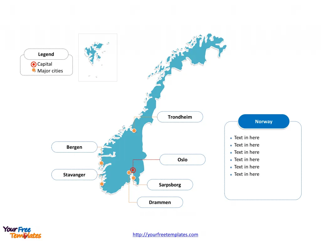
The Norway Map Template includes two slides. Norway map with 19 counties, labeling with major counties, Insigne, Akershus, Hordaland, and Rogaland. Norway map labeling with national capital and major cities, Oslo, Bergen, Stavanger, Trondheim, Drammen, and Sarpsborg.
Norway, located in Northern Europe on the western part of the Scandinavian Peninsula, shares its borders with Sweden, Finland, and Russia. With a population of approximately 5.4 million, Norway is known for its high standard of living, extensive social welfare system, and abundant natural resources.
The country’s economy is heavily reliant on petroleum and natural gas, which account for a significant portion of its export revenue. Additionally, Norway has a strong maritime tradition and a thriving seafood industry. The nation’s commitment to environmental conservation and sustainability is evident through its investments in renewable energy and strict environmental regulations. Norway’s strategic location, coupled with its focus on technological innovation and sustainable development, positions it as a key player in the global economy while maintaining a high quality of life for its residents.
Slide 1, Norway map labeled with capital and major cities.
Its capital and largest city is Oslo, other major cities including Bergen, Stavanger, Trondheim, Drammen, and Sarpsborg.
Capital and Major Cities on Norway map
Oslo: The Capital of Norway
Oslo, the capital of Norway, serves as the country’s political, economic, and cultural center. With a population of around 700,000, it is a thriving city known for its contemporary architecture, rich history, and vibrant arts scene. The city houses the Norwegian government, royal family, and a range of cultural institutions, making it a significant hub for both locals and tourists.
Bergen: The Cultural Hub of Vestland
Bergen, the capital of Vestland county, is renowned for its picturesque harbor, colorful wooden houses, and vibrant cultural life. This UNESCO World Heritage City offers a blend of historical charm, modern amenities, and access to stunning natural landscapes, attracting visitors from around the world.

Trondheim: Norway’s Historical Gem
Trondheim, the largest city in Trøndelag county, is steeped in history and is home to the impressive Nidaros Cathedral, a national sanctuary and pilgrimage site. The city’s rich cultural heritage, academic institutions, and scenic surroundings make it a captivating destination for residents and visitors alike.
Stavanger: The Oil Capital
Stavanger, the administrative center of Rogaland county, is a key player in Norway’s oil and gas industry. Beyond its economic significance, the city boasts a charming old town, a lively cultural scene, and access to stunning fjords, making it a popular destination for nature enthusiasts and urban explorers alike.
Drammen: A Riverside Gem
Drammen, the largest city in and the administrative center of Buskerud county, is celebrated for its riverside location, cultural events, and outdoor recreational opportunities. The city’s blend of urban amenities and natural beauty makes it an appealing place for residents and visitors to enjoy.
Slide 2, Norway map labeled with major administration districts.
Norway map shows the country divided into 19 counties, Østfold, Akershus, Insigne, Hedmark, Oppland, Buskerud, Vestfold, Telemark, Aust-Agder, Vest-Agder, Rogaland, Hordaland, Sogn og Fjordane, Møre og Romsdal, Sør-Trøndelag, Nord-Trøndelag, Nordland, Troms, and Finnmark. Every individual political subdivision is an editable shape.

Insigne, Akershus, Hordaland, and Rogaland: Major Counties
Insigne, Akershus, Hordaland, and Rogaland are significant counties in Norway, each offering a unique blend of cultural, historical, and natural attractions. These counties, with their diverse landscapes and vibrant cities, contribute to the rich tapestry of Norway’s regional identity and play a pivotal role in the country’s economic and cultural landscape.
Looking for Premium maps, please visit our affiliate site: https://editablemaps.com/ or https://ofomaps.com/
Size: 140K
Type: PPTX
Aspect Ratio: Standard 4:3
Click the blue button to download it.
Download the 4:3 Template
Aspect Ratio: Widescreen 16:9
Click the green button to download it.
Download the 16:9 Template


![Digital Marketing: Opportunity, Strategy, and Action Digital marketing is search engine optimization (SEO), search engine marketing (SEM), content marketing, influencer marketing, content automation, campaign marketing, data-driven marketing,[8] e-commerce marketing, social media marketing, social media optimization, e-mail direct marketing, Display advertising, e–books.](https://yourfreetemplates.com/wp-content/uploads/2019/08/Digital_marketing_1-100x70.gif)


