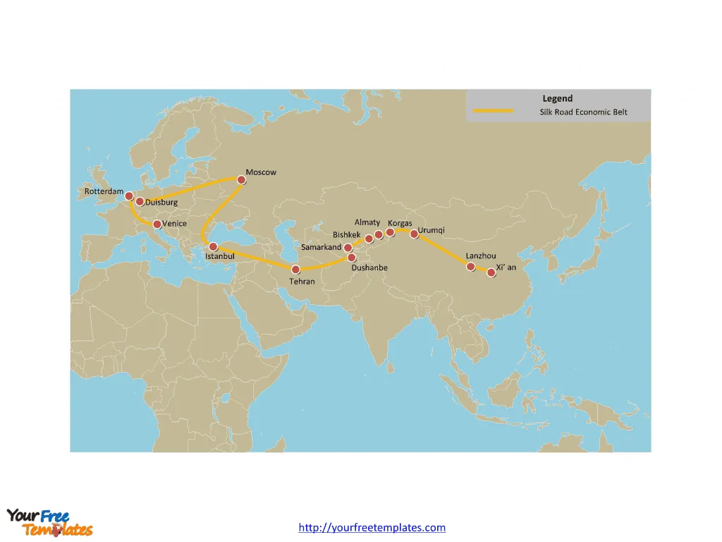
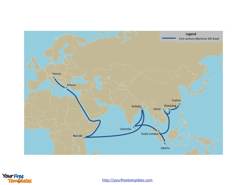
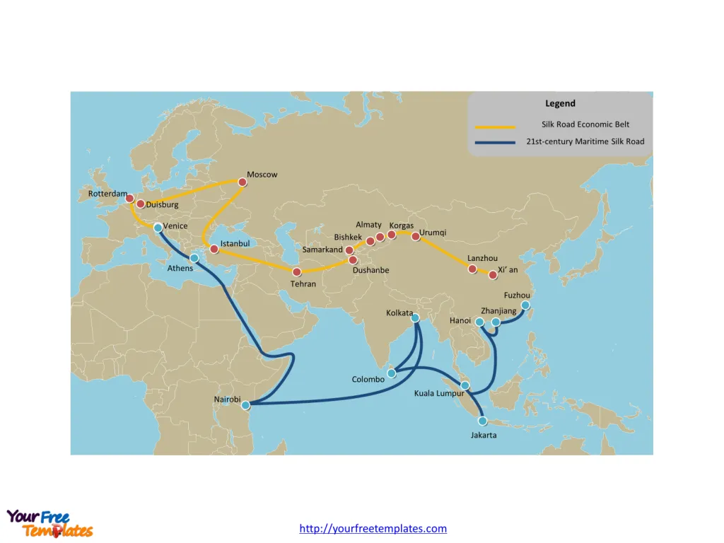
The Silk Road Map Template includes three slides. One Belt One Road map labeled with the lines of Silk Road Economic Belt and 21st-century Maritime Silk Road, and major cities along it.
Introduction
The Silk Road and the One Belt One Road (OBOR) initiative are undoubtedly two of the most ambitious and strategically interconnected infrastructure projects in recent history. While the Silk Road represents the ancient network of trade routes that connected Asia, Europe, and Africa, the OBOR initiative seeks to revive and expand upon this historical legacy by creating a modern-day economic and cultural corridor.
The Silk Road: A Historic Legacy
The Silk Road, often romanticized as a path of exotic goods and cultural exchange, was a series of ancient overland trade routes that spanned thousands of kilometers. It facilitated the exchange of goods, ideas, and knowledge between civilizations from China to the Mediterranean. The name “Silk Road” originated from the lucrative trade in silk, which was highly prized by the Roman Empire.
Slide 1, Silk road map labeled with Silk Road Economic Belt
The Silk Road Economic Belt
The Silk Road Economic Belt, a key component of the OBOR initiative, aims to revitalize and expand the ancient land-based trading routes. This ambitious project envisions the creation of a network of road, rail, and pipelines that will connect China‘s east coast with Europe. The economic belt will consist of regional corridors branching off the main land bridge, connecting countries such as Mongolia, Russia, South East Asia, India, Pakistan, Bangladesh, and Central Asia.

The One Belt One Road Initiative: Vision and Objectives
The OBOR initiative, proposed by Chinese President Xi Jinping in 2013, has multifaceted objectives. It seeks to promote economic development, enhance regional connectivity, foster cultural exchange, and strengthen diplomatic relations between China and participating nations. It is not just about physical infrastructure; it is a comprehensive strategy to create an expanded, interdependent market for China, boost its economic and political influence, and foster the conditions for technological advancement.
Slide 2, One Belt One Road map labeled with 21st-century Maritime Silk Road
The 21st Century Maritime Silk Road
In addition to the land-based routes, the OBOR initiative includes the 21st Century Maritime Silk Road, a planned sea route that will integrate port and coastal infrastructure projects. This maritime corridor will link China’s east coast with Europe, India, Africa, and the Pacific, traversing the South China Sea and the Indian Ocean. It aims to facilitate seamless trade and connectivity through the development of port facilities, trade routes, and maritime cooperation.

Opportunities and Challenges
The OBOR initiative presents numerous opportunities and challenges for participating countries, investors, and businesses. Let’s examine some of these key aspects.
Economic Opportunities
For countries along the OBOR routes, the initiative offers tremendous economic opportunities. Investments in infrastructure, energy, and trade facilitation can spur economic growth, create jobs, and enhance regional connectivity. The development of modern transportation networks can reduce logistical costs and improve access to global markets, benefiting both exporting and importing nations.
Cultural Exchange and Diplomatic Relations
The silk road initiative aims to foster cultural exchange and strengthen diplomatic ties between participating countries. By promoting people-to-people connectivity, educational exchanges, and cultural collaborations, the initiative seeks to enhance mutual understanding and cooperation. This cultural diplomacy can lead to stronger bilateral relations and increased goodwill among nations.
Slide 3, Silk Road map with two routes combined
Environmental Sustainability
As the silk road initiative promotes infrastructure development on a massive scale, it is crucial to address environmental sustainability. Sustainable practices, such as incorporating green technologies, adopting eco-friendly construction methods, and protecting biodiversity, should be integral to the implementation of infrastructure projects. This approach can mitigate the environmental impact and ensure a more sustainable future for the regions involved.
Geopolitical Considerations and Balancing Interests
The OBOR initiative has geopolitical implications that require careful navigation. It is essential to strike a balance between competing interests, address concerns of participating nations, and ensure equitable distribution of benefits. Transparent governance, fair trade practices, and respect for national sovereignty are crucial for maintaining stability and fostering long-term cooperation.

Conclusion
The Silk Road and the One Belt One Road initiative represent a visionary approach to revitalizing ancient trade routes for a modern world. The OBOR initiative’s comprehensive strategy encompasses economic development, cultural exchange, and diplomatic relations. As the initiative gains momentum, it presents both opportunities and challenges for participating countries and stakeholders. By effectively addressing these challenges and leveraging the opportunities, the OBOR initiative has the potential to reshape global trade, foster regional cooperation, and promote sustainable development.
Looking for Premium maps, please visit our affiliate site: https://editablemaps.com/ or https://ofomaps.com/
Size: 382K
Type: PPTX
Aspect Ratio: Standard 4:3
Click the blue button to download it.
Download the 4:3 Template
Aspect Ratio: Widescreen 16:9
Click the green button to download it.
Download the 16:9 Template


