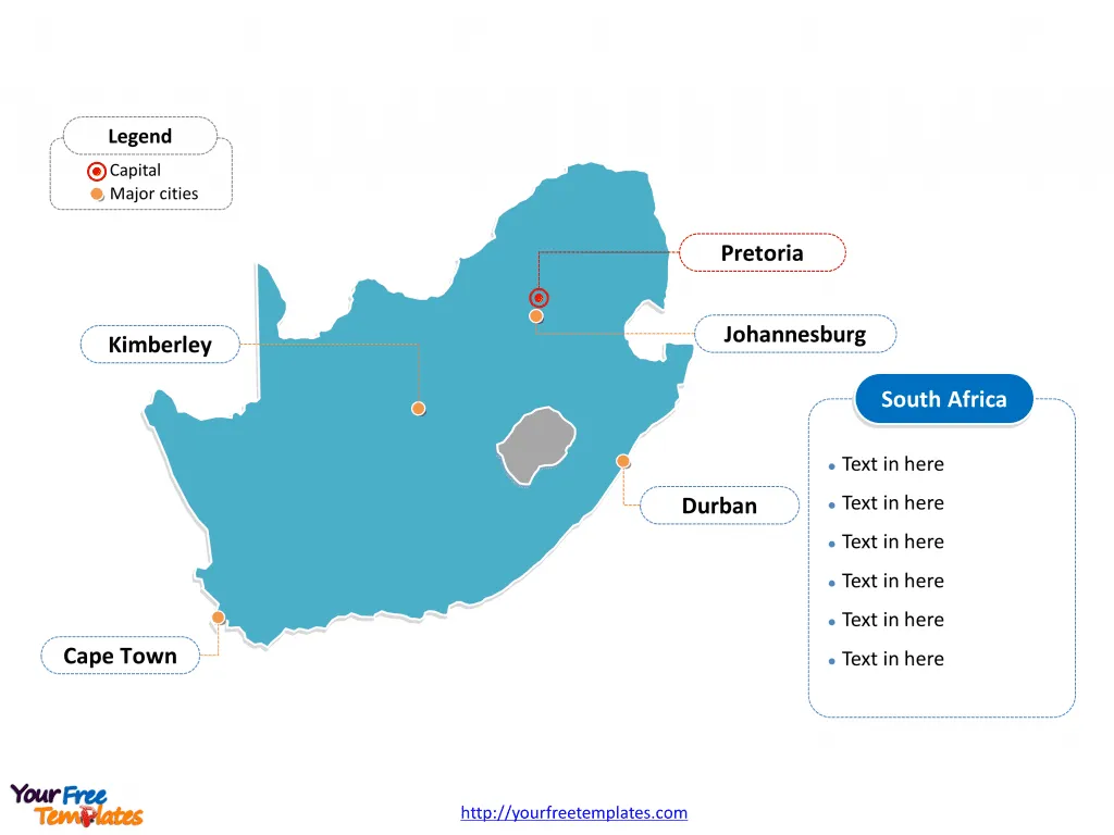
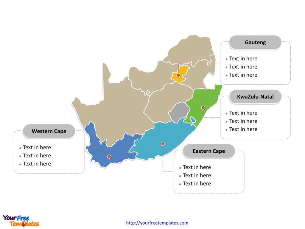
Free South Africa map template has two slides. One is for South Africa map with 9 provinces, highlighting Gauteng, KwaZulu-Natal, Eastern Cape, and Western Cape provinces. The other is for South Africa map labeled with Pretoria, Durban, Kimberley, and Cape Town cities.
South Africa: Location and Neighboring Countries
South Africa is a captivating country located at the southernmost tip of the African continent. It is uniquely positioned, bordered by both the Atlantic Ocean on the western side and the Indian Ocean on the eastern side, which converge at the country’s southern point, creating a beautiful and diverse coastline that stretches for over 2,500 kilometers (about 1,553 miles).
Geographic Location
South Africa lies between latitudes 22° and 35° S, and longitudes 16° and 33° E. The country’s distinct geographical location not only offers a variety of climates and landscapes but also positions it as a significant hub for maritime routes.
Neighboring Countries
South Africa shares its borders with six countries and encloses two independent countries, making it a central nation on the African continent. Here’s a closer look at its neighbors:
- Namibia: To the northwest, South Africa shares a long border with Namibia, extending along the Orange River. The arid Namib Desert runs along part of the border area.
- Botswana: North of South Africa, Botswana shares a border that stretches across the Kalahari Desert, known for its rich wildlife and game reserves.
- Zimbabwe: To the northeast, the border with Zimbabwe is defined by the Limpopo River, an area rich in both cultural history and natural beauty.
- Mozambique: East of South Africa, Mozambique is bordered by the Indian Ocean. The two countries are separated by the picturesque landscapes of the Lebombo Mountains.
- Eswatini (formerly Swaziland): Situated to the southeast, the kingdom of Eswatini is one of the two countries entirely surrounded by South Africa (the other being Lesotho). It shares a significant portion of its western border with South Africa.
- Lesotho: Unique among South Africa’s neighbors, Lesotho is an enclaved country entirely surrounded by South African territory. It is situated in the Drakensberg Mountains and is the only independent state in the world that lies entirely above 1,000 meters in elevation.
Slide 1, South Africa map labeled with capital and major cities.
South Africa, a nation of incredible diversity and beauty, boasts a rich tapestry of cultures, languages, and landscapes. From the bustling urban centers to the breathtaking provinces, each area has its unique charm and history. This exploration takes us through the major cities of Bloemfontein, Johannesburg, Pretoria, Durban, Kimberley, and Cape Town, as well as the significant provinces of Gauteng, KwaZulu-Natal, Eastern Cape, and Western Cape.
Its capital and largest city is Pretoria (executive), Bloemfontein (judicial), Cape Town (legislative), and Johannesburg respectively, other major cities including Pretoria, Durban, Kimberley, and Cape Town on South Africa map .

Major Cities labeled on South Africa map
Bloemfontein
Known as the ‘City of Roses’ for its abundance of these flowers, Bloemfontein is not only the judicial capital of South Africa but also the capital city of the Free State Province. It is a city that prides itself on its cultural and historical significance, housing the Supreme Court of Appeal and the National Museum. Bloemfontein is a serene yet vibrant city, offering a blend of urban and natural attractions.
Johannesburg
The heartbeat of South Africa, Johannesburg, often referred to as Jozi or Joburg, is the country’s largest city and the financial hub. It’s a city of contrasts, with bustling markets, towering skyscrapers, and the poignant Apartheid Museum that chronicles South Africa’s history of racial segregation. The vibrant neighborhood of Soweto, Mandela’s former home, draws visitors from around the world.
Pretoria
Pretoria, the administrative capital of South Africa, is a city steeped in history and adorned with thousands of jacaranda trees that bloom beautifully in spring. It is home to the Union Buildings, the official seat of the South African government, and numerous embassies, making it a crucial center for political affairs in South Africa.
Durban
With its sunny beaches, Durban is a tropical, vibrant city on the east coast of South Africa, in the province of KwaZulu-Natal. Renowned for its bustling harbor, Durban is the busiest port in the country. The city is a melting pot of cultures, offering an array of Indian, African, and colonial influences, not to mention the stunning Golden Mile beachfront.
Kimberley
Kimberley, located in the Northern Cape, is famously known as the ‘Diamond City’ for its historical significance in the diamond mining industry. It hosts the Big Hole, the largest hand-dug excavation in the world, now a fascinating museum. Kimberley is a city that embodies the entrepreneurial spirit and provides insights into the diamond rush era.
Cape Town
Cape Town, the legislative capital of South Africa and the capital of the Western Cape Province, is renowned for its breathtaking natural beauty, from the iconic Table Mountain to the scenic Cape Point. The city is a cultural melting pot, with a vibrant arts scene, rich history, and exquisite culinary diversity. Cape Town’s Robben Island, where Nelson Mandela was imprisoned, is a UNESCO World Heritage Site and a poignant reminder of the country’s struggle for freedom.
Slide 2, South Africa map labeled with major Provinces.
South Africa is a country divided into nine provinces, Eastern Cape, Free State, Gauteng, KwaZulu-Natal, Limpopo, Mpumalanga, North West, Northern Cape, and Western Cape. Every individual political subdivision is an editable shape.

Major Provinces highlighted in South Africa map
Gauteng
Though the smallest province in terms of land area, Gauteng is the powerhouse of South Africa. It encompasses Johannesburg and Pretoria, making it the economic and administrative hub of the country. Gauteng is a vibrant province with a dynamic mix of urban development, cultural diversity, and significant historical sites.
KwaZulu-Natal
Bordering the Indian Ocean, KwaZulu-Natal is known for its beaches, mountains, and the rich Zulu culture. The province includes Durban, offering a warm climate year-round, and the historic battlefields where Zulu, British, and Boer forces once clashed. It is a region of great biodiversity, from the coastal forests to the peaks of the Drakensberg.
Eastern Cape
The Eastern Cape is a province of great natural beauty and diversity, with pristine beaches, untouched forests, and the rugged Wild Coast. It is also the birthplace of Nelson Mandela, and its rich history is integral to the South African heritage. The province offers a mix of adventure, cultural experiences, and relaxation.
Western Cape
The Western Cape, with Cape Town as its capital, is famous for its stunning landscapes, including the Cape Winelands, the Garden Route, and the Karoo desert. It is a province of extraordinary scenic beauty, rich flora and fauna, and a flourishing wine industry. The Western Cape’s diverse cultures and vibrant arts scene make it a popular destination for tourists and locals alike.
Detailed South Africa map of political administrative divisions please refer to Wikipedia South Africa.
Size: 102K
Type: PPTX
Aspect Ratio: Standard 4:3
Click the blue button to download it.
Download the 4:3 Template
Aspect Ratio: Widescreen 16:9
Click the green button to download it.
Download the 16:9 Template


