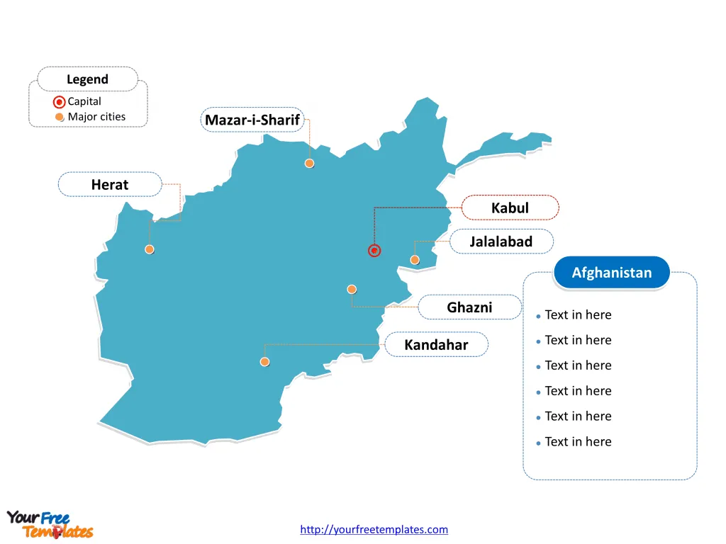
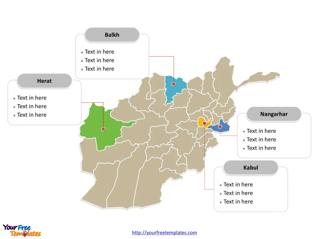
The Afghanistan Map Template includes two slides. Afghanistan map with 34 provinces for the administrative purpose, highlighting Balkh, Herat, Kabul, and Nangarhar provinces. Afghanistan map of outline labeled with Kabul, Herat, Jalalabad, Mazar-i-Sharif, Ghazni, and Kandahar cities.
Afghanistan is a landlocked country located in South Asia and Central Asia. It is bordered by several countries:
- To the north, Afghanistan shares its border with Turkmenistan, Uzbekistan, and Tajikistan.
- To the east, it is bordered by Pakistan.
- To the south and southeast, it shares its borders with Iran and Pakistan.
- To the west, Afghanistan’s neighbor is Iran.
This strategic location has historically made Afghanistan a crossroads for trade and culture, but it has also presented challenges due to its proximity to conflict-prone regions.
Slide 1, Afghanistan map with outline labeled with capital and major cities.
Afghanistan has a population of approximately 32 million, ranking the 42nd most populous country around the world. Kabul has been the capital and largest city of this country, other major cities including Herat, Jalalabad, Mazar-i-Sharif, Ghazni, and Kandahar.
Major cities on Afghanistan Map
Kabul
Kabul, the capital and largest city of Afghanistan, is located in the eastern part of the country. It serves as the political, cultural, and economic hub of Afghanistan. The city has a rich history dating back over 3,500 years and has been an important center for trade and culture. Despite the challenges it has faced due to conflict, Kabul remains a vibrant city with a diverse population and a blend of modern and traditional elements.
Herat
Herat, located in the western part of Afghanistan, is one of the country’s oldest and most significant cities. Known for its exquisite minarets, mausoleums, and historical sites, Herat has been a center of trade and learning along the ancient Silk Road. The city’s rich cultural heritage and strategic location make it an important urban center in Afghanistan.

Jalalabad
Jalalabad, situated in the eastern part of the country, is a key city in the region. It is known for its fertile agricultural land and has historically been an important center for trade and commerce. The city’s location, close to the border with Pakistan, has contributed to its significance as a trading hub.
Mazar-i-Sharif
Mazar-i-Sharif, located in the north of Afghanistan, is the capital of Balkh province. It is known for its historic shrines, particularly the Blue Mosque, which is a revered site for Muslims. Mazar-i-Sharif has been a center of trade and culture for centuries and continues to play a pivotal role in the region’s economic and cultural landscape.
Ghazni
Ghazni, situated in eastern Afghanistan, has a rich history and is renowned for its ancient architecture and cultural heritage. The city has been an important center for the arts, literature, and learning throughout its history. Despite the challenges posed by conflict, Ghazni remains an integral part of Afghanistan’s historical and cultural tapestry.
Kandahar
Kandahar, located in the south of the country, is one of Afghanistan’s largest cities and holds immense historical and cultural significance. It has been an important center for trade and agriculture and is often referred to as the “birthplace of the Taliban.” The city has a long and storied history, with its roots dating back to ancient times.
Slide 2, Afghanistan Map labeled with major provinces
Afghanistan is a country divided into 34 provinces (wilayats), which are Badakhshan, Badghis, Baghlan, Balkh, Bamyan, Daykundi, Farah, Faryab, Ghazni, Ghor, Helmand, Herat, Jowzjan, Kabul, Kandahar, Kapisa, Khost, Kunar, Kunduz, Laghman, Logar, Maidan Wardak, Nangarhar, Nimruz, Nuristan, Paktia, Paktika, Panjshir, Parwan, Samangan, Sar-e Pol, Takhar, Urozgan, Zabul. Every individual political subdivision is an editable shape.

Major provinces on Afghanistan Map
Balkh
Balkh province, with Mazar-i-Sharif as its capital, is located in the north of Afghanistan. It is known for its historical and cultural significance, with ancient ruins and historical sites that attract visitors from around the world.
Herat
Herat province, with its capital city of the same name, is situated in the west of Afghanistan. The province is celebrated for its rich cultural heritage, including its distinctive art, music, and poetry, and serves as a vital economic and trade center.
Kabul
Kabul province, home to the capital city, is at the heart of Afghanistan’s political and economic activities. It is the most populous province in the country and is a melting pot of diverse cultures and traditions.
Nangarhar
Nangarhar province, with Jalalabad as its capital, is located in the east of Afghanistan. The province is known for its fertile agricultural land and is a key center for trade and commerce, especially due to its proximity to the border with Pakistan.
In conclusion, Afghanistan’s major cities and provinces are not only geographically diverse but also steeped in history, culture, and significance. Each city and province contributes to the rich tapestry of Afghanistan’s past, present, and future.
Looking for Premium maps, please visit our affiliate site: https://editablemaps.com/ or https://ofomaps.com/
Size: 98K
Type: PPTX
Aspect Ratio: Standard 4:3
Click the blue button to download it.
Download the 4:3 Template
Aspect Ratio: Widescreen 16:9
Click the green button to download it.
Download the 16:9 Template


