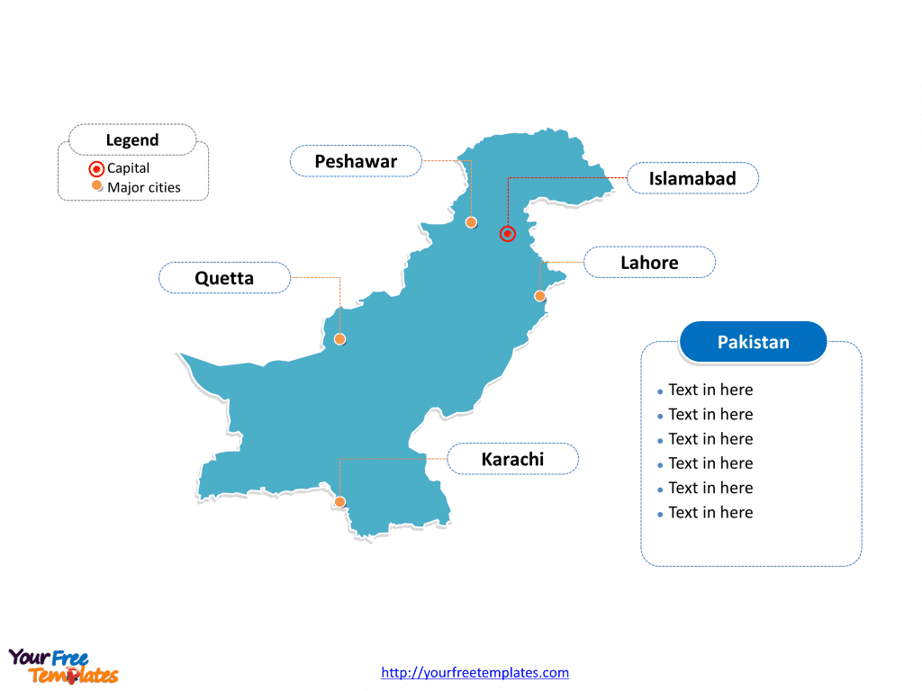
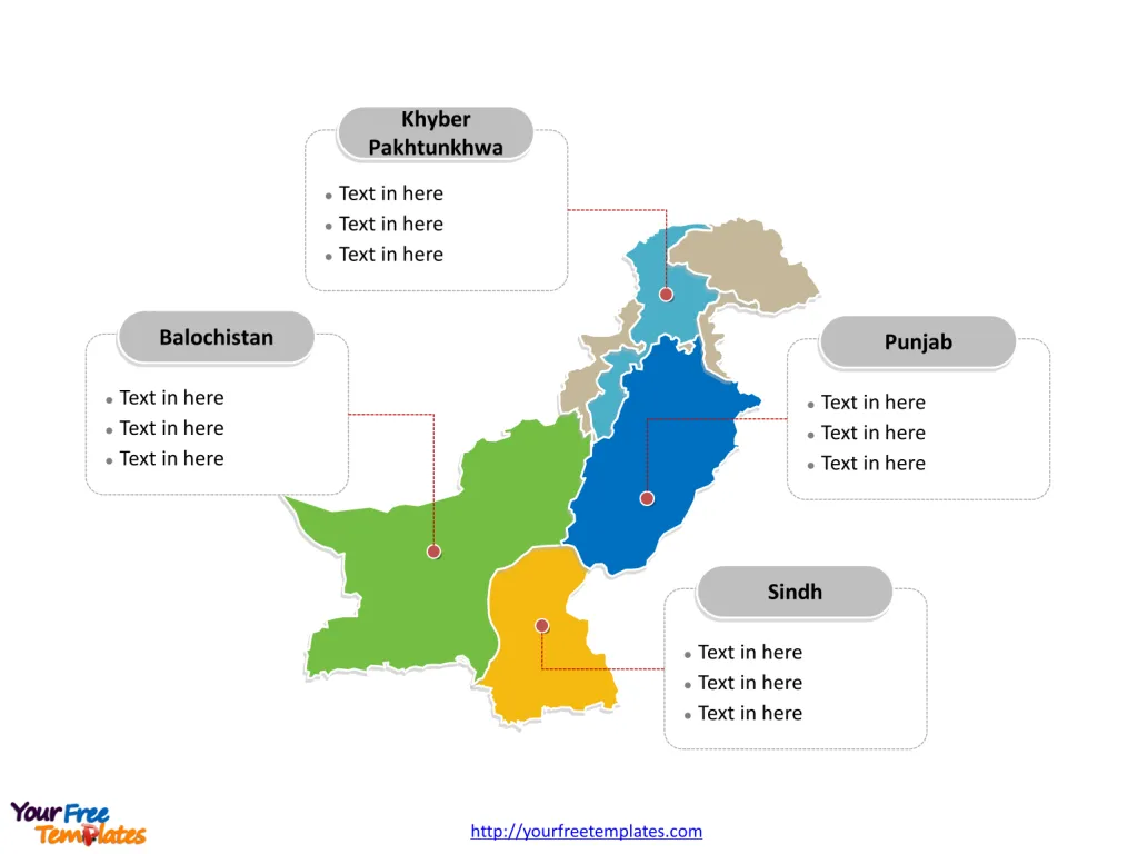
Pakistan map with four provinces, one federal capital territory, two autonomous and disputed territories, and a group of federally administered tribal areas, labeling with major provinces, Punjab, Sindh, Khyber Pakhtunkhwa, and Balochistan. Pakistan map labeling with national capital and major cities, Islamabad, Karachi, Lahore, Peshawar, and Quetta.
Pakistan is strategically located in South Asia, sharing its borders with four countries. To the east, it is bordered by India, which is its largest neighbor. Afghanistan and Iran lie to the west, offering gateways to Central Asia and the Middle East, respectively. China shares a border with Pakistan to the north, providing a link to East Asia. Additionally, Pakistan boasts a southern coastline along the Arabian Sea, enhancing its geographical significance with maritime connections. This unique positioning places Pakistan at a crossroads of different cultures and geopolitical interests, contributing to its diverse heritage and strategic importance in the region.
Slide 1, Pakistan map labeled with capital and major cities.
Pakistan, a country with a rich cultural heritage and diverse landscapes, is home to several major cities each unique in its offerings. Below is an exploration of its prominent cities: Islamabad, Karachi, Lahore, Peshawar, and Quetta, along with an overview of the major provinces: Punjab, Sindh, and Khyber Pakhtunkhwa.
Its capital and largest city is Islamabad and Karachi respectively, other major cities including Lahore, Peshawar, and Quetta on our Pakistan map.
Major Cities
Islamabad
Islamabad, the capital city of Pakistan, is known for its high standard of living, safety, and abundant greenery. It is a well-planned city divided into sectors and zones, making it organized and easy to navigate. The city serves as the political seat of Pakistan and houses all foreign embassies. Landmarks include Faisal Mosque, the largest mosque in South Asia, and the Pakistan Monument, which symbolizes national unity.
Karachi
Karachi, the largest city in Pakistan, is often referred to as the country’s economic powerhouse. Located on the coast of the Arabian Sea, Karachi is the main seaport and financial center of Pakistan. It is a vibrant city, known for its diverse culture, bustling markets, and dynamic nightlife. Key attractions include the Karachi Port, Clifton Beach, and the Quaid-e-Azam’s Mausoleum, the final resting place of Muhammad Ali Jinnah, the founder of Pakistan.
Lahore
Lahore, the capital of Punjab province, is renowned for its rich history, vibrant culture, and gastronomic delights. It is considered the cultural heart of Pakistan, hosting many of the country’s arts festivals. Historical sites such as the Lahore Fort and Shalimar Gardens reflect the city’s Mughal past. Lahore is also famous for its food streets and the Lahore Literary Festival, attracting intellectuals and foodies alike.

Peshawar
Peshawar, the capital of Khyber Pakhtunkhwa, is one of the oldest cities in Asia, with a history that spans at least 2,500 years. Situated near the Khyber Pass, it has been a cultural crossroads for Central and South Asia. The city is known for its historical significance, vibrant bazaars, and hospitable people. Notable sites include the Peshawar Museum, Qissa Khwani Bazaar, and the historic Bala Hisar Fort.
Quetta
Quetta, the capital of Balochistan, is known as the “Fruit Garden of Pakistan” due to the diverse variety of fruits produced here. Located at a high altitude, it has a different climate compared to other major cities of Pakistan, with snowy winters and cool summers. Quetta is famous for its bazaars, handicrafts, and natural beauty, with nearby attractions like Hanna Lake and Hazarganji Chiltan National Park.
Slide 2, Pakistan map labeled with major administration districts.
Pakistan is a country consists of four provinces, one federal capital territory, two autonomous and disputed territories, and a group of federally administered tribal areas. The most populated province is Punjab. Every individual political subdivision is an editable shape.
Major Provinces are highlighted on our Pakistan map
Punjab
Punjab is the most populous province of Pakistan and serves as an agricultural heartland. The province is known for its colorful culture, historical sites, and culinary delights. Punjab’s major cities include Lahore, Rawalpindi, and Faisalabad, each adding to the province’s economic and cultural richness. The province celebrates festivals like Basant and Lahore Literary Festival with great fervor.
Sindh
Sindh, with Karachi as its capital, is the second-largest province by population. It has a rich history, with the Indus Valley Civilization being one of the world’s oldest. Sindh is known for its crafts, particularly textiles and pottery. The annual Sindh Festival celebrates its cultural heritage, showcasing music, art, and literature.
Khyber Pakhtunkhwa
Khyber Pakhtunkhwa (KPK), with Peshawar as its capital, is known for its rugged terrain and tribal areas. It is rich in culture and history, with influences from Central Asia and the Middle East. The province is a gateway to Pakistan’s tourist destinations in the north, including the Swat Valley and K2, the world’s second-highest mountain. KPK is celebrated for its traditional music, dance, and craftsmanship.

Conclusion
Pakistan’s major cities and provinces each contribute uniquely to the country’s cultural, economic, and social fabric. From the bustling streets of Karachi to the historical depth of Lahore, the serene beauty of Islamabad, the ancient allure of Peshawar, and the natural wonders of Quetta, Pakistan offers a diverse experience. The provinces of Punjab, Sindh, and Khyber Pakhtunkhwa further enrich this experience with their distinct traditions, landscapes, and histories. Together, they paint a comprehensive picture of Pakistan’s rich and diverse identity.
Find out more about this country in the official government website.
Size: 116K
Type: PPTX
Aspect Ratio: Standard 4:3
Click the blue button to download it.
Download the 4:3 Template
Aspect Ratio: Widescreen 16:9
Click the green button to download it.
Download the 16:9 Template


