The Philippines Map PowerPoint Template includes two slides, that is, the country outline map and map of Philippines with regions. Firstly, our Philippines Editable Map blank templates have capital and major cities on it. Secondly, there are 17 regions in our blank map templates, in our map of Philippines PowerPoint template of divisions, labeling the most populated Regions.
The Philippines, an archipelago in Southeast Asia, is known for its rich history, diverse culture, and stunning landscapes. It is also home to bustling cities and key regions that contribute to its economic and cultural vibrancy. Here’s a closer look at some of the major cities including Manila, Quezon City, Davao City, Cagayan de Oro, Cebu City, Zamboanga, and significant regions like Calabarzon, the National Capital Region, Central Luzon, and Central Visayas.
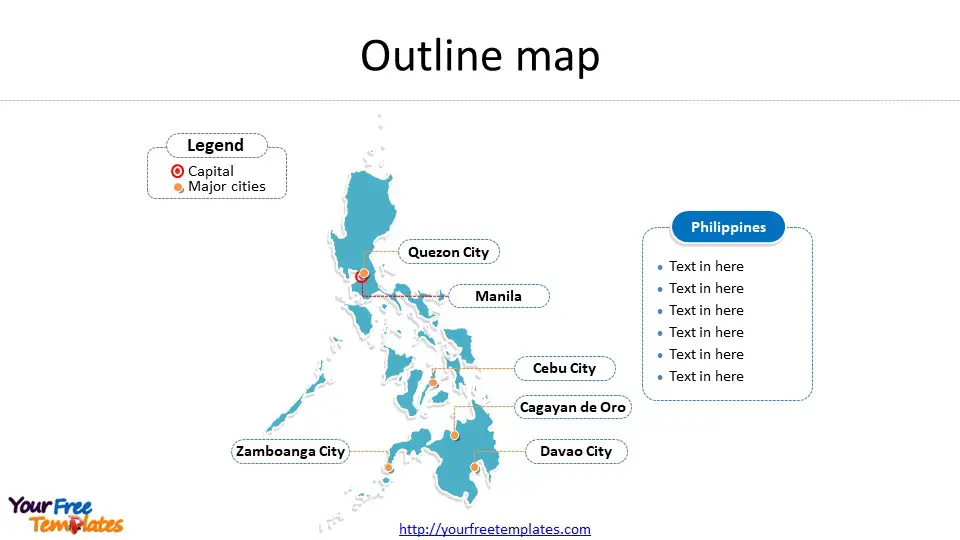
Slide 1, Philippines map of outline with capital and major cities on Map of Philippines.
Major Cities – Philippines map location cities
Manila: The capital city of the Philippines, Manila, is the heart of the National Capital Region. It is a densely populated city brimming with historical landmarks, government offices, and bustling markets. The iconic Intramuros, a historic walled area within the city, tells the story of the Philippines’ colonial past.
Quezon City: Once the national capital, Quezon City is known for its government institutions, universities, and entertainment hubs. It is the largest city in terms of population and area in Metro Manila. The city is also home to the Quezon Memorial Circle, a national park and shrine.
Davao City: Located in Mindanao, Davao City is the largest city in the Philippines in terms of land area. It is known for its durian plantations, Mount Apo (the highest mountain in the country), and as the hometown of President Rodrigo Duterte.
Cagayan de Oro: Often referred to as the “City of Golden Friendship,” Cagayan de Oro is the gateway to Northern Mindanao. It is famous for its white-water rafting and kayaking adventures.
Cebu City: Known as the “Queen City of the South,” Cebu City is a significant cultural and commercial center in the Visayas region. It is famous for its Sinulog Festival, historical landmarks like Magellan’s Cross, and as a gateway to the region’s stunning beaches and diving spots.
Zamboanga: Located in Mindanao, Zamboanga City is known for its unique culture, blending Muslim, Christian, and indigenous influences. It is famous for its colorful vintas (traditional boats) and Fort Pilar, a 17th-century Spanish fortress.

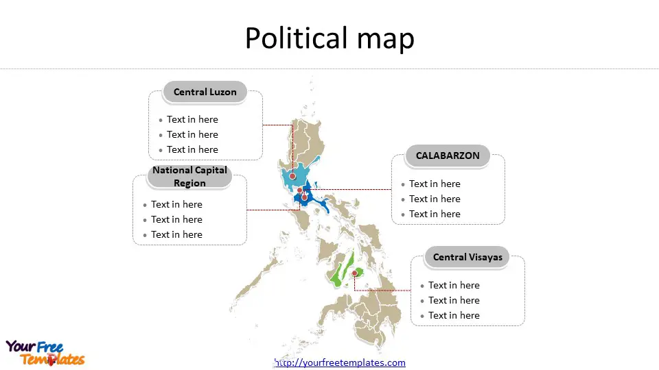
Slide 2, Philippines map of political divisions labeled with major regions.
Philippines is a country composed of 17 regions, they are he National Capital Region (NCR), Cordillera Administrative Region (CAR), the Ilocos Region, Cagayan Valley, Central Luzon, Calabarzon, Mimaropa, The Bicol Region, Western Visayas, Central Visayas, Eastern Visayas, Zamboanga Peninsula, Northern Mindanao, the Davao Region, Soccsksargen, Caraga, and the Bangsamoro Autonomous Region in Muslim Mindanao (BARMM).
Major Regions on Philippines country map
Calabarzon: An acronym for the provinces of Cavite, Laguna, Batangas, Rizal, and Quezon, Calabarzon is a major industrial and economic region located in the southern part of Luzon. It is known for its historical sites, beautiful landscapes, and as a major contributor to the country’s manufacturing sector.
National Capital Region (NCR): The NCR, or Metro Manila, is the political, economic, and cultural center of the Philippines. It comprises 16 cities, including Manila, Quezon City, and Makati, the country’s financial hub.
Central Luzon: This region is known as the “Rice Granary of the Philippines” due to its vast rice fields. It features significant urban centers like Angeles City and San Fernando, and natural attractions like Mount Pinatubo.
Central Visayas: Comprising the islands of Cebu, Bohol, Negros Oriental, and Siquijor, Central Visayas is known for its historical significance, vibrant festivals, and world-class beaches and diving spots.
Every individual political subdivision is an editable shape. Detailed Philippines editable map of political administrative divisions please refer to Wikipedia Philippines.

Size: 297K
Type: PPTX
Aspect Ratio: Standard 4:3
Click the blue button to download it.
Download the 4:3 Template
Aspect Ratio: Widescreen 16:9
Click the green button to download it.
Download the 16:9 Template


