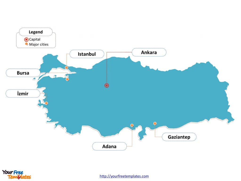
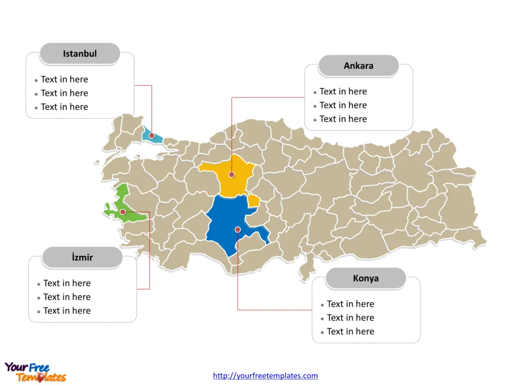
The Turkey Map Template includes two slides.Turkey Map with 81 provinces, highlighting Istanbul, Ankara, İzmir, and Konya. Turkey map labeled with Istanbul, Ankara, İzmir, Bursa, Adana, and Gaziantep cities.
Turkey is strategically positioned at the crossroads of Europe and Asia, serving as a bridge between the two continents. Its unique geographical location encompasses the Anatolian peninsula in western Asia and a small enclave in Thrace in the southeastern tip of Europe.
Turkey is surrounded by eight countries: Greece and Bulgaria to the northwest, Georgia to the northeast, Armenia, Azerbaijan (Nakhchivan exclave), and Iran to the east, and Iraq and Syria to the south. It also has maritime borders with Cyprus, situated in the Mediterranean Sea. The country’s extensive coastline lies along the Aegean Sea to the west, the Mediterranean Sea to the south, and the Black Sea to the north, making it a country with diverse cultural influences and a rich historical legacy.
Slide 1, Turkey Map labeled with capital and major cities.
Turkey is a country that bridges Europe and Asia, offering a unique blend of cultures, histories, and landscapes. Among its bustling cities and significant provinces, Istanbul, Ankara, İzmir, Bursa, Adana, and Gaziantep stand out as major capitals, while the provinces of Istanbul, Ankara, İzmir, and Konya are key to understanding Turkey’s cultural and economic fabric.
Major Capitals on Turkey map
Istanbul
Istanbul, not just a major city but a historic marvel, straddles two continents. With a staggering population of approximately 15.2 million people by the end of 2021, it is Turkey’s largest city and cultural epicenter. Known for its rich history, Istanbul is home to iconic landmarks such as the Hagia Sophia and the Blue Mosque, embodying the city’s diverse heritage.
Ankara
Ankara, the heart of Turkey’s political life and the second-largest city, serves as the capital. It houses all the foreign embassies, government buildings, and has a population of about 5.15 million people. The city is known for its modern infrastructure and vibrant cultural scene.

İzmir
İzmir, with a population of nearly 2.95 million, is the third-largest city in Turkey and a significant Aegean port 2. It is known for its cosmopolitan atmosphere, historical sites, and as a hub for trade and tourism.
Bursa
Bursa, the fourth-largest city, is famed for its historical significance as the first Ottoman capital and a major industrial center. With over 3.1 million inhabitants, it is known for its green spaces, thermal baths, and as a leading textile industry hub 2.
Adana
Adana, with a populous of approximately 1.77 million, is renowned for its vibrant culinary scene, including the famous Adana kebab. This city combines agricultural richness with industrial growth, standing as a vital economic center in the southern part of Turkey 2.
Gaziantep
Gaziantep, a city with a deep historical background and a population reaching 1.71 million, is celebrated for its culinary heritage, especially its baklava. It is also an economic powerhouse, with a strong industrial base 2.
Slide 2, Turkey Map labeled with major administration districts.
Turkey is a country subdivided into 81 provinces for administrative purposes, Adana, Adıyaman, Afyonkarahisar, Ağrı, Aksaray, Amasya, Ankara, Antalya, Ardahan, Artvin, Aydın, Balıkesir, Bartın, Batman, Bayburt, Bilecik, Bingöl, Bitlis, Bolu, Burdur, Bursa, Çanakkale, Çankırı, Çorum, Denizli, Diyarbakır, Düzce, Edirne, Elazığ, Erzincan, Erzurum, Eskişehir, Gaziantep, Giresun, Gümüşhane, Hakkâri, Hatay, Iğdır, Isparta, Istanbul, İzmir, Kahramanmaraş, Karabük, Karaman, Kars, Kastamonu, Kayseri, Kilis, Kırıkkale, Kırklareli, Kırşehir, Kocaeli, Konya, Kütahya, Malatya, Manisa, Mardin, Mersin, Muğla, Muş, Nevşehir, Niğde, Ordu, Osmaniye, Rize, Sakarya, Samsun, Şanlıurfa, Siirt, Sinop, Şırnak, Sivas, Tekirdağ, Tokat, Trabzon, Tunceli, Uşak, Van, Yalova, Yozgat, and Zonguldak. Every individual political subdivision is an editable shape.
Major Provinces on Turkey map
Istanbul Province
The Istanbul province encapsulates the city’s vastness, extending into both Europe and Asia. It’s a global city, leading in finance, culture, and education, with a significant impact on Turkey’s economy and tourism.
Ankara Province
The Ankara province mirrors the city’s importance, being the center of government and administration. It plays a crucial role in the country’s political, economic, and cultural activities, fostering development and innovation.

İzmir Province
İzmir province, with its capital city’s charm, is a crucial economic zone, especially in trade and tourism. Its strategic location on the Aegean coast makes it a gateway for international relations and cultural exchange.
Konya Province
Konya, known for its rich Seljuk history, spiritual significance with Rumi’s legacy, and agricultural contributions, is a blend of tradition and modernity. It is pivotal in promoting Turkey’s cultural heritage and economic development through its vast plains and industrial growth.
In conclusion, Turkey’s major cities and provinces are a testament to its dynamic evolution, blending ancient traditions with modern advancements. From Istanbul’s historical grandeur to Ankara’s political heartbeat, İzmir’s Aegean charm to Bursa’s Ottoman legacy, Adana’s culinary richness, and Gaziantep’s cultural heritage, Turkey is a vibrant mosaic of cultures. Simultaneously, the provinces of Istanbul, Ankara, İzmir, and Konya highlight the diverse yet unified nature of Turkey, driving its progress and cultural vibrancy.
Looking for Premium maps, please visit our affiliate site: https://ofomaps.com/
Size: 173K
Type: PPTX
Aspect Ratio: Standard 4:3
Click the blue button to download it.
Download the 4:3 Template
Aspect Ratio: Widescreen 16:9
Click the green button to download it.
Download the 16:9 Template


