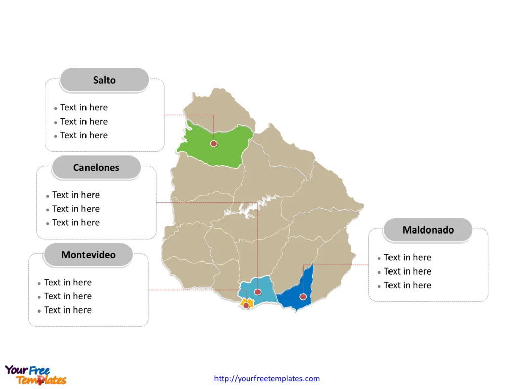
The Uruguay Map Template includes two slides. Uruguay map with 19 departments, labeling major departments, Montevideo, Canelones, Maldonado, and Salto. Uruguay Outline map labeled with capital and major cities, Montevideo, Salto, Paysandú, Rivera, Maldonado, and Tacuarembó.
Uruguay, a country located in Southern South America, is bordered by the South Atlantic Ocean, Argentina and Brazil. With a population of approximately 3,416,264, Uruguay has a well-developed free market economy, characterized by an export-oriented agricultural sector and a high level of social spending. The country has sought to expand trade within the Common Market of the South (Mercosur) and with non-Mercosur members. In terms of its economic overview, Uruguay experienced financial difficulties in the late 1990s and early 2000s, but rebounded with an average annual economic growth of 8% during the 2004-08 period. The real GDP (purchasing power parity) of Uruguay was estimated at $75.06 billion in 2020.
In terms of neighboring countries, Uruguay shares its borders with Argentina and Brazil, and its strategic location provides it with opportunities for regional distribution and trade.
Slide 1, Uruguay map labeled with capital and major cities.
Montevideo is the capital and largest city of Uruguay, other major cities including Salto, Paysandú, Rivera, Maldonado, and Tacuarembó.
Capital and Major Cities on Uruguay map
Montevideo: The Vibrant Capital
Montevideo, the capital and largest city of Uruguay, stands as a bustling metropolis with a rich historical and cultural heritage. With a population of over 1.3 million, Montevideo serves as a significant economic, cultural, and administrative hub, showcasing a captivating blend of traditional charm and modern development. The city’s picturesque coastal location and vibrant atmosphere make it a compelling destination for visitors and a dynamic hub for residents.

Salto: A Riverside Gem
Salto, situated on the east bank of the Río Uruguay, is celebrated for its scenic riverside beauty and historical significance. With a population of over 99,000, Salto offers a blend of cultural allure and natural landscapes, making it a captivating destination for visitors and a serene haven for residents.
Paysandú: Historical and Cultural Hub
Paysandú, known for its rich historical and cultural heritage, boasts a population of approximately 73,000. The city offers a blend of traditional charm and modern developments, making it an inviting destination for those seeking a genuine taste of Uruguayan culture.
Rivera: A Melting Pot of Cultures
Rivera, located near the Brazilian border, is celebrated for its vibrant atmosphere and cultural diversity. With a population of over 64,000, Rivera offers a unique blend of cultural heritage and urban vibrancy, making it a compelling destination for visitors and a thriving hub for residents.
Maldonado: Coastal Charm
Maldonado, situated along Uruguay’s southern coast, stands as a captivating destination with a population of over 55,000. The city’s stunning coastal views and rich cultural scene contribute to its allure as a serene haven for residents and a popular destination for travelers.
Tacuarembó: Rural Tranquility
Tacuarembó, known for its tranquil rural setting and warm community spirit, boasts a population of over 51,000. The city offers a unique glimpse into Uruguay’s rural charm and cultural traditions, shaping the region’s inviting and serene atmosphere.
Slide 2, Uruguay map labeled with major administration districts.
Uruguay is a country divided into 19 departments: Artigas, Canelones, Cerro Largo, Colonia, Durazno, Flores, Florida, Lavalleja, Maldonado, Montevideo, Paysandú, Río Negro, Rivera, Rocha, Salto, San José, Soriano, Tacuarembó, Treinta y Tres. The most populated provinces are Canelones, Maldonado, Montevideo and Salto. Every individual political subdivision is an editable shape.
Major Departments on Uruguay map
Montevideo Department
The Montevideo Department, encompassing the capital city, serves as a significant administrative, economic, and cultural hub, playing a pivotal role in shaping Uruguay’s national identity and development.

Canelones Department
The Canelones Department, with Ciudad de la Costa as a notable city, offers a blend of coastal allure and urban vibrancy, contributing to the region’s diverse urban and rural fabric.
Maldonado Department
The Maldonado Department, with Maldonado as a significant city, is celebrated for its coastal charm and cultural significance, adding to Uruguay’s rich tapestry of cultural and natural attractions.
Salto Department
The Salto Department, with Salto as a major city, offers a blend of historical significance and natural allure, shaping the region’s vibrant and inviting atmosphere.
Uruguay’s capital, major cities, and significant departments collectively contribute to the country’s cultural, historical, and economic landscape, making it a captivating destination for visitors and a serene haven for residents. The diverse array of urban centers and significant departments showcases Uruguay’s unique blend of historical heritage, urban vibrancy, and natural beauty, making it a compelling subject for exploration and discovery.
Looking for Premium maps, please visit our affiliate site: https://editablemaps.com/ or https://ofomaps.com/
Size: 118K
Type: PPTX
Aspect Ratio: Standard 4:3
Click the blue button to download it.
Download the 4:3 Template
Aspect Ratio: Widescreen 16:9
Click the green button to download it.
Download the 16:9 Template


