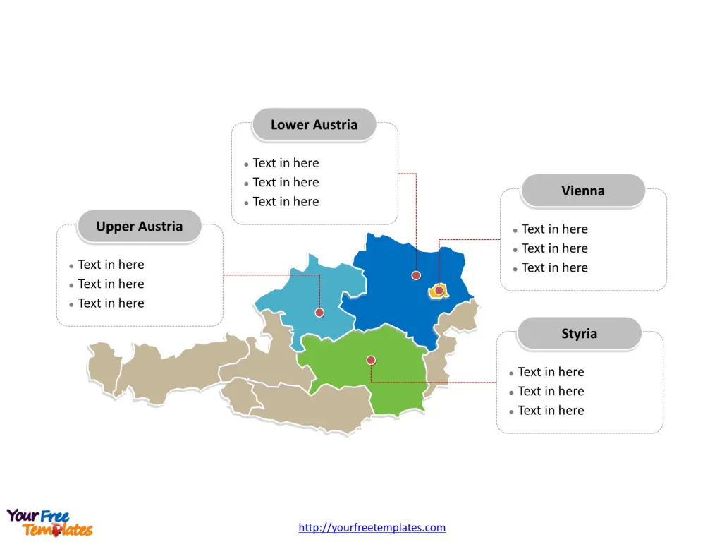
The Austria Map Template includes two slides. Austria map with 9 states, labeling with major states, Vienna, Lower Austria, Upper Austria, and Styria. Austria map labeling with national capital and major cities, Vienna, Graz, Linz, Salzburg, and Innsbruck.
Location: Austria, a landlocked country in Central Europe, is bordered by Germany and the Czech Republic to the north, Slovakia and Hungary to the east, Slovenia and Italy to the south, and Switzerland and Liechtenstein to the west.
Population: Austria has a population of approximately 8.9 million people. The capital and largest city, Vienna, is home to over 1.9 million residents.
Economy: Austria boasts a highly developed social market economy and a high standard of living. Key sectors of its economy include services, industry, and agriculture, with a focus on machinery, metallurgical products, chemicals, and tourism. Vienna, apart from being the political and cultural center, is also a major economic hub.
Neighboring Countries: Austria shares its borders with several countries, including Czech Republic, Germany, Hungary, Italy, Liechtenstein, Slovakia, Slovenia, and Switzerland. Its central location in Europe has historically positioned it as a vital crossroads for trade and cultural exchange.
Slide 1, Austria map labeled with capital and major cities.
Its capital and largest city is Vienna, other major cities including Graz, Linz, Salzburg, and Innsbruck.
Capital and Major Cities on Austria map
Vienna: The Capital Vienna, the capital and largest city of Austria, is renowned for its cultural heritage, classical music, and imperial palaces. With a population of over 1.9 million, Vienna is a global city with a rich history, stunning architecture, and a thriving arts and culinary scene. It is also a significant center for international diplomacy and hosts various United Nations offices.

Graz: The Styrian Jewel Graz, the second-largest city in Austria, is located in the southeastern part of the country. With a population of around 300,000, Graz is the capital of the state of Styria and is celebrated for its medieval old town, vibrant arts scene, and prestigious universities.
Linz: The Danube City Linz, situated in the north of Austria, is the third-largest city in the country, with a population of approximately 205,000. It is an important industrial and technological center, known for its contributions to the fields of steel manufacturing and renewable energy.
Salzburg: The Birthplace of Mozart Salzburg, known as the birthplace of Wolfgang Amadeus Mozart, is famous for its baroque architecture and is a UNESCO World Heritage Site. With a population of around 155,000, Salzburg is a cultural gem and a prominent center for music and arts.
Innsbruck: The Alpine Capital Innsbruck, nestled in the heart of the Alps, is the capital of the state of Tyrol. With a population of approximately 130,000, Innsbruck is a popular destination for winter sports and outdoor activities, offering a unique blend of urban life and alpine adventure.
Slide 2, Austria map labeled with major administration districts.
Austria map shows the country divided into 9 states, Burgenland, Carinthia, Lower Austria, Salzburg, Styria, Tyrol, Upper Austria, Vienna, and Vorarlberg. Every individual political subdivision is an editable shape. The most populated states in this country are Vienna, Styria, Upper Austria and Lower Austria.
Major States on Austria map
Vienna The state of Vienna is both a city and a state, serving as the administrative, political, and cultural center of Austria. It is the most populous state and is known for its historical significance and vibrant urban life.

Lower Austria Lower Austria, surrounding the capital, is the largest state in Austria, featuring a diverse landscape of vineyards, forests, and historic towns. It is an essential agricultural and industrial region.
Upper Austria Upper Austria is situated in the north of the country and is a significant economic and industrial hub, particularly known for its manufacturing and technology sectors.
Styria Styria, located in the southeast, is known for its natural beauty, including vineyards, thermal springs, and the Dachstein mountain range. It is an important region for agriculture, tourism, and cultural heritage.
Looking for Premium maps, please visit our affiliate site: https://editablemaps.com/ or https://ofomaps.com/
Size: 88K
Type: PPTX
Aspect Ratio: Standard 4:3
Click the blue button to download it.
Download the 4:3 Template
Aspect Ratio: Widescreen 16:9
Click the green button to download it.
Download the 16:9 Template


