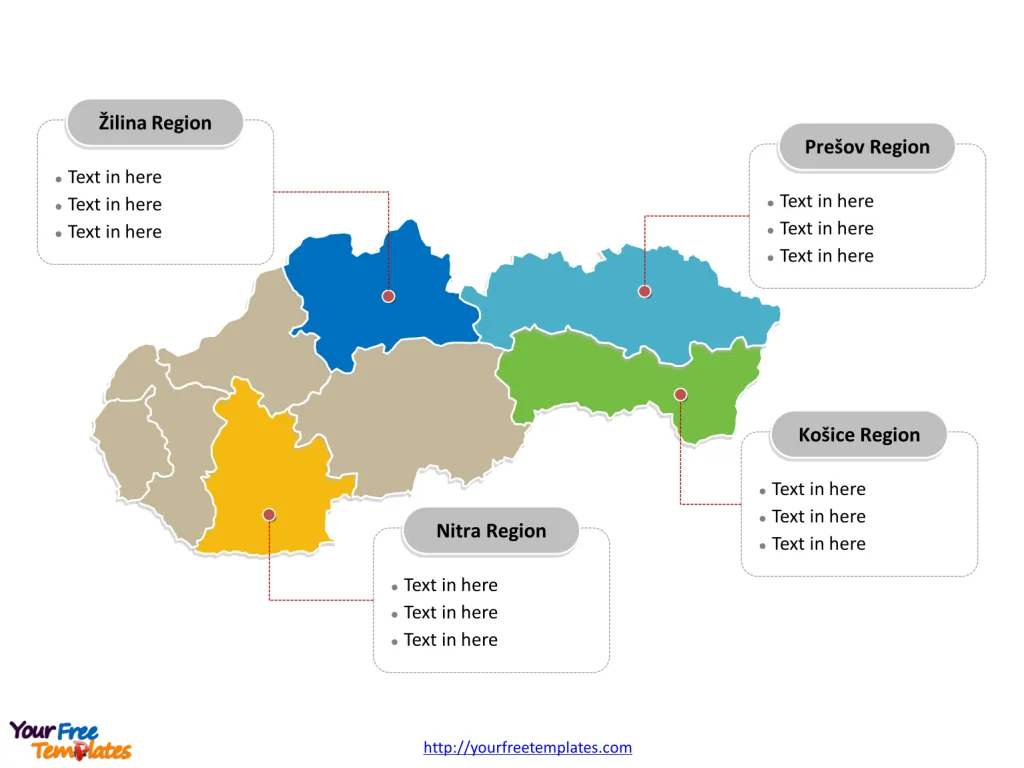
The Slovakia Map Template includes two slides. Slovakia map with 8 krajov, labeling with major regions, Prešov Region, Košice Region, Nitra Region, and Žilina Region. Slovakia map labeling with national capital and major cities, Bratislava, Košice, Prešov, Žilina, and Banská Bystrica.
Slovakia, located in Central Europe, is bordered by several countries, including Ukraine to the east, Poland to the north, Hungary to the south, Austria to the west, and the Czech Republic to the northwest. With a population of approximately 5.5 million, Slovakia is known for its rich cultural heritage, picturesque landscapes, and a mix of historical and modern attractions.
The country’s economy is driven by industries such as automotive manufacturing, machinery, electronics, and information technology. Additionally, Slovakia benefits from its strategic location within the European Union, facilitating trade and investment opportunities. The nation’s commitment to economic reforms and integration into the global market has positioned it as a key player in the region, while its historical sites, natural beauty, and vibrant cities make it an enticing destination for visitors.
Slide 1, Slovakia Map labeled with capital and major cities.
Its capital and largest city is Bratislava, other major cities including Košice, Prešov, Žilina, and Banská Bystrica.
Capital and Major Cities on Slovakia map
Bratislava: The Capital City
Bratislava, the capital of Slovakia, serves as the country’s economic, political, and cultural hub. With a population of over 475,000, it is known for its rich history, vibrant arts scene, and picturesque setting along the Danube River.
Košice: A Cultural Gem
Košice, the second-largest city in Slovakia, is celebrated for its historical significance, charming old town, and a dynamic blend of cultural influences. The city’s rich heritage and modern energy make it a captivating destination for residents and visitors.

Prešov: Embracing History and Tradition
Prešov, located in the eastern part of the country, is renowned for its historical architecture, lively markets, and a deep-rooted connection to Slovak culture and traditions. The city’s vibrant atmosphere and historical landmarks make it a noteworthy stop for explorers.
Žilina: Where Nature Meets Urbanity
Žilina, nestled in the northwestern part of Slovakia, offers a harmonious blend of urban amenities and access to the country’s stunning natural landscapes. The city’s picturesque surroundings and cultural offerings make it an appealing destination.
Banská Bystrica: A Blend of History and Modernity
Banská Bystrica, located in the heart of Slovakia, boasts a rich historical legacy, charming architecture, and a thriving arts scene. The city’s strategic location and cultural significance make it an intriguing place to explore.
Slide 2, Slovakia Map labeled with major administration districts.
Slovakia is a country with 8 krajov, known as region, Bratislava Region, Trnava Region, Nitra Region, Trenčín Region, Banská Bystrica Region, Žilina Region, Košice Region, and Prešov Region. Every individual political subdivision is an editable shape.
Major Regions on Slovakia map
Prešov Region
Prešov Region, with its diverse landscapes and historical significance, contributes to Slovakia’s rich tapestry of culture and natural beauty. The region’s blend of urban centers and rural charm offers a unique experience for residents and visitors.

Košice Region
Košice Region, home to the city of Košice, is known for its cultural vibrancy, historical heritage, and scenic surroundings. The region’s emphasis on preserving traditions and embracing modernity makes it a captivating destination.
Nitra Region
Nitra Region, anchored by the city of Nitra, offers a seamless blend of historical charm and modern vitality. The region’s cultural richness and agricultural heritage contribute to Slovakia’s diverse regional identity.
Žilina Region
Žilina Region, with its stunning natural landscapes and thriving urban centers, showcases Slovakia’s commitment to preserving its natural beauty and fostering economic development.
Looking for Premium maps, please visit our affiliate site: https://editablemaps.com/ or https://ofomaps.com/
Size: 97K
Type: PPTX
Aspect Ratio: Standard 4:3
Click the blue button to download it.
Download the 4:3 Template
Aspect Ratio: Widescreen 16:9
Click the green button to download it.
Download the 16:9 Template


