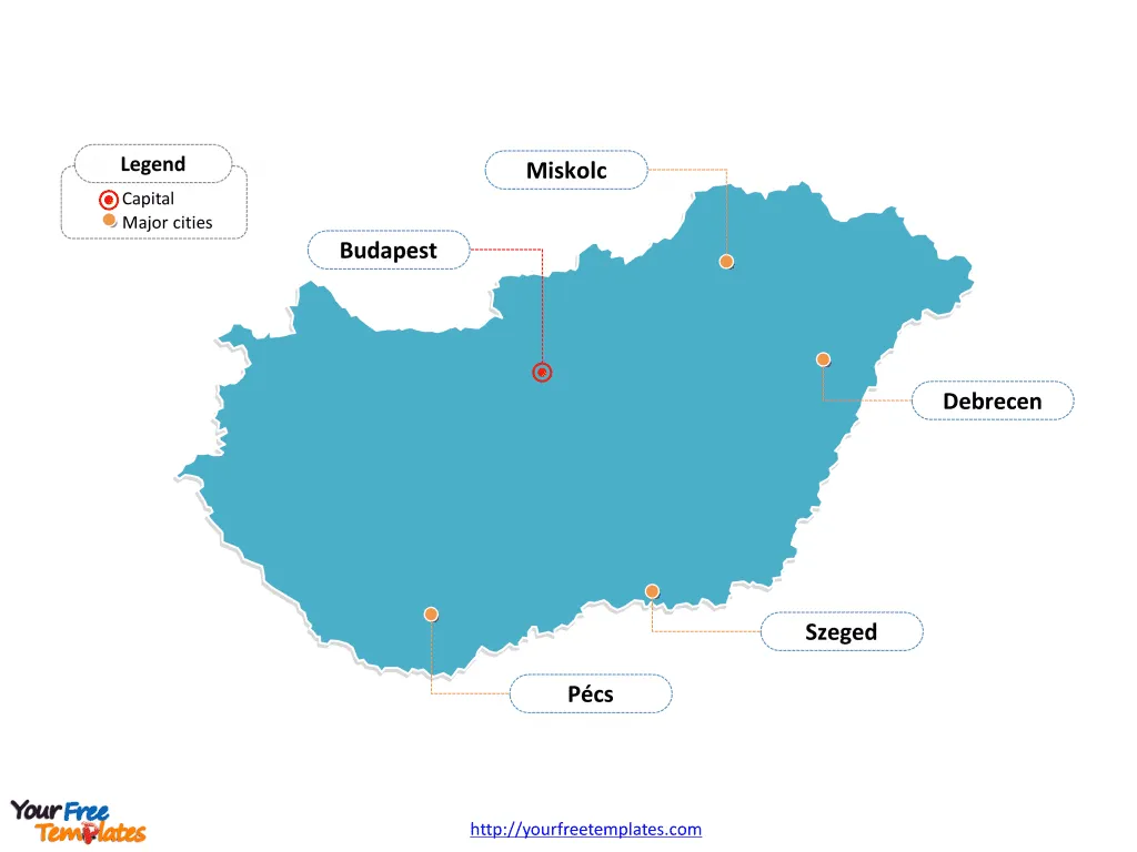
The Hungary Map Template includes two slides. Hungary map with 19 counties and the capital city, labeling with major counties, Capital City of Budapest, Pest, Borsod-Abaúj-Zemplén, and Hajdú-Bihar. Hungary map labeling with national capital and major cities, Budapest, Debrecen, Szeged, Miskolc, and Pécs.
Location: Hungary is a landlocked country in Central Europe. It is bordered by Slovakia to the north, Ukraine to the northeast, Austria to the west, Slovenia and Croatia to the south, and Serbia and Romania to the east.
Population: Hungary has a population of approximately 9.6 million people. The capital and largest city, Budapest, is home to over 1.7 million residents.
Economy: Hungary has a mixed economy, with key sectors including manufacturing, agriculture, and services. The country has a well-developed industrial base and is known for industries such as automotive manufacturing, pharmaceuticals, and electronics. Budapest, as the economic center, plays a significant role in Hungary’s economy.
Neighboring Countries: Hungary shares its borders with several countries, including Slovakia, Ukraine, Austria, Slovenia, Croatia, Serbia, and Romania. Its central location in Europe positions it as a key player in regional trade and diplomacy.
Slide 1, Hungary map labeled with capital and major cities.
Its capital and largest city is Budapest, other major cities including Debrecen, Szeged, Miskolc, and Pécs.
Capital and Major Cities on Hungary map
Budapest: The Capital Budapest, the capital and largest city of Hungary, is situated along the Danube River. With a population of over 1.7 million, Budapest is a prominent cultural, commercial, and industrial hub. It is known for its stunning architecture, rich history, and vibrant arts and music scene. The city is also home to numerous UNESCO World Heritage Sites, including Buda Castle and the banks of the Danube.

Debrecen: The Cultural Center Debrecen, located in the eastern part of the country, is Hungary’s second-largest city, with a population of around 200,000. It is a major cultural and educational center, hosting the country’s oldest and most renowned university, the University of Debrecen.
Szeged: A City of Science and Education Szeged, situated on the southern Great Plain, is known for its commitment to science and education. With a population of over 160,000, it is home to the University of Szeged and is a significant center for pharmaceutical research and development.
Miskolc and Pécs Miskolc, located in the northeast, is Hungary’s fourth-largest city, known for its heavy industry, particularly in steel and machinery. Pécs, in the southwest, is a city with a rich cultural heritage, boasting a well-preserved medieval old town and a vibrant arts scene.
Slide 2, Hungary map labeled with major administration districts.
Hungary is a country with 19 counties and the capital city, Bács-Kiskun, Baranya, Békés, Borsod-Abaúj-Zemplén, Capital City of Budapest, Csongrád, Fejér, Győr-Moson-Sopron, Hajdú-Bihar, Heves, Jász-Nagykun-Szolnok, Komárom-Esztergom, Nógrád, Pest, Somogy, Szabolcs-Szatmár-Bereg, Tolna, Vas, Veszprém, and Zala. Every individual political subdivision is an editable shape.
Major Counties on Hungary Map
Capital City of Budapest The Capital City of Budapest is a county in its own right, housing the administrative, economic, and cultural heart of Hungary. It is divided into 23 districts and is the most populous and economically significant county in the country.

Pest Pest County surrounds the capital and is the most populous county in Hungary. It is an important industrial and commercial region, playing a key role in the country’s economy.
Borsod-Abaúj-Zemplén Borsod-Abaúj-Zemplén is located in the northeast and is known for its natural beauty, including the Bükk National Park. It is also a significant industrial region, with a focus on mining and heavy industry.
Hajdú-Bihar Hajdú-Bihar, in the eastern part of Hungary, is known for its agricultural activities and is a vital transportation hub, hosting the country’s second-largest city, Debrecen.
Looking for Premium maps, please visit our affiliate site: https://editablemaps.com/ or https://ofomaps.com/
Size: 104K
Type: PPTX
Aspect Ratio: Standard 4:3
Click the blue button to download it.
Download the 4:3 Template
Aspect Ratio: Widescreen 16:9
Click the green button to download it.
Download the 16:9 Template


