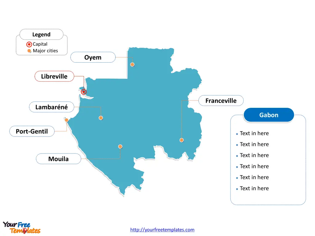
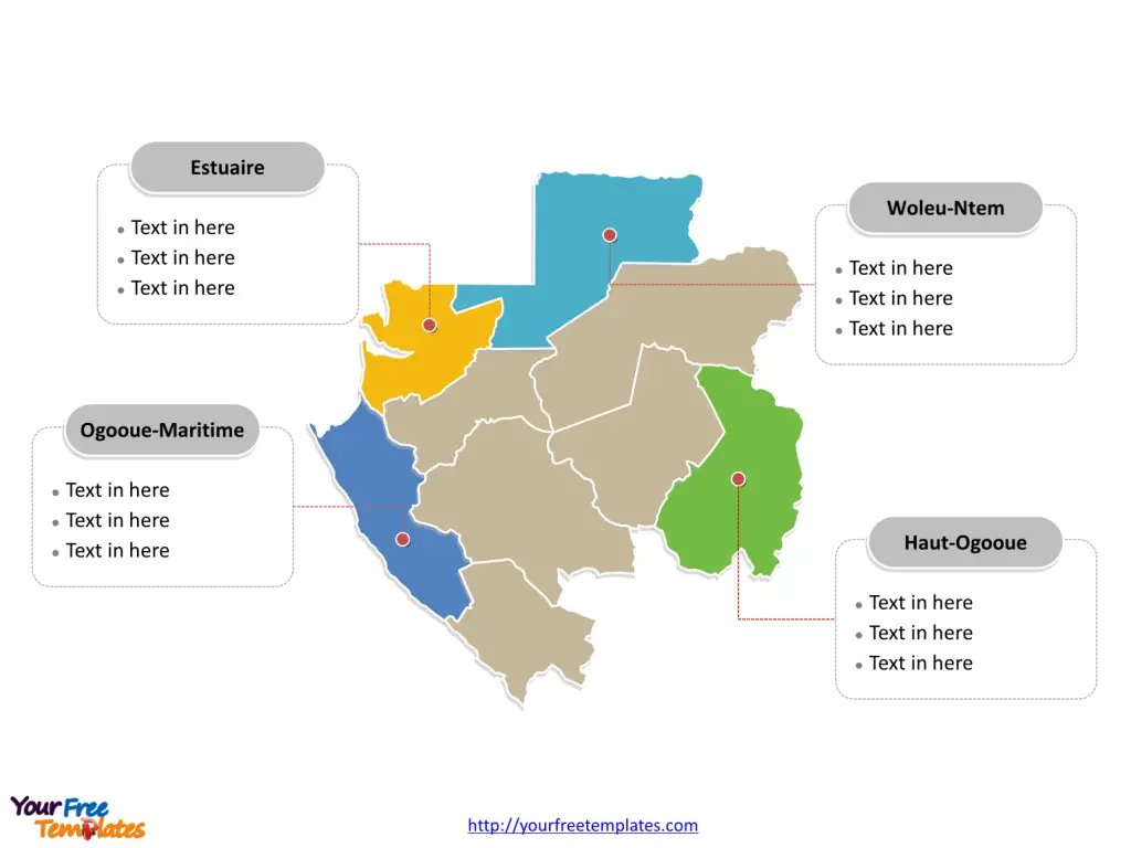
The Gabon Map Template includes two slides. Gabon map with 9 provinces, highlighting Estuaire, Haut-Ogooué, Ogooué-Maritime, and Woleu-Ntem provinces. Gabon map outline labeled with Libreville, Franceville, Port-Gentil, Oyem, Mouila, and Lambaréné cities.
Gabon, located in Central Africa, is a sparsely populated country with a population of approximately 2 million people. The nation is bordered by Cameroon, Equatorial Guinea, and Republic of the Congo, with a coastline along the Atlantic Ocean. Known for its vast natural resources and dense rainforests, Gabon actively protects its tropical forest, making it a net carbon absorber and promoting carbon neutrality initiatives. Its offical language is French, with close relations with thr former European country of France.
The country has a highly urbanized population, with over 80% residing in urban areas, and the two main cities, Libreville and Port-Gentil, are home to nearly 59% of the population. Despite being one of the wealthiest countries in Central Africa, Gabon faces challenges in translating its resource wealth into sustainable, inclusive growth. The World Bank is supporting Gabon’s transition towards sustainable economic growth through various initiatives, including digital transformation, enhanced social services, and increased investment in non-oil sectors.
Slide 1, Gabon map labeled with capital and major cities.
Major Cities on Gabon Map
Libreville
Libreville, the capital and largest city of Gabon, is a bustling metropolis located on the Komo River near the Gulf of Guinea. With a population of over 700,000, it serves as a major port and trade center. The city is home to the largest airport in Gabon, the Libreville International Airport, and hosts a range of industries including shipbuilding, sawmills, and brewing. Notable attractions in Libreville include the National Museum of Arts and Traditions, St. Marie’s Cathedral, and cultural villages.

Franceville
Franceville, the third largest urban center in Gabon, lies on the Mpassa River at the end of the N3 Road and the Trans-Gabon Railway. Initially established as a settlement for former slaves, the city is home to a primate medical research institute, St Hilaire’s Church, and a golf course. The town’s infrastructure is relatively well-developed, with various tourist attractions, including waterfalls, making it an appealing destination.
Port-Gentil
Port-Gentil, also known as Mandji, is Gabon’s second-largest city and the primary seaport in the country. It serves as the center for Gabon’s petroleum and timber industries. Despite being geographically isolated from other parts of the country by remote forest areas, the city is well-connected through the Port-Gentil International Airport, facilitating both domestic and international travel.
Oyem
Oyem, the capital of the Woleu-Ntem province, ranks as the fourth largest urban center in Gabon. Positioned on the River Ntem and the N2 road, the city’s economy revolves around the production and export of coffee, cocoa, potatoes, and rubber. Notable facilities in Oyem include a hospital, a government secondary school, churches, and an agricultural school.
Mouila
As the fifth largest urban center in Gabon, Mouila is situated in the Ngounié province. The town’s economy is supported by various agricultural activities, with the production and export of goods such as cocoa playing a significant role. It is also home to essential amenities such as hospitals and educational institutions.
Lambaréné
Lambaréné, with a population of over 38,000, is a key town located in the Moyen-Ogooué province. The town is notable for its contributions to the region’s economic and social landscape, housing various facilities including hospitals and educational institutions.
Slide 2, Gabon map labeled with major administration districts.
Gabon map shows the country divided into nine provinces, Estuaire, Haut-Ogooué, Moyen-Ogooué, Ngounié , Nyanga, Ogooué-Ivindo, Ogooué-Lolo, Ogooué-Maritime, and Woleu-Ntem. The most populated provinces are Estuaire, Haut-Ogooué, Ogooué-Maritime, and Woleu-Ntem. Every individual political subdivision is an editable shape.
Major Provinces on Gabon Map
Estuaire
The Estuaire province, home to Libreville and Owendo, is a crucial economic and administrative hub in Gabon, with a strong focus on trade and commerce.

Haut-Ogooué
The Haut-Ogooué province, where Franceville and Moanda are located, is known for its strategic significance in the country’s mining and industrial activities, particularly in manganese extraction.
Ogooué-Maritime
The Ogooué-Maritime province, centered around Port-Gentil, is a vital seaport and a hub for Gabon’s petroleum and timber industries, contributing significantly to the country’s economy.
Woleu-Ntem
The Woleu-Ntem province, with Oyem as its capital, is a region known for its agricultural output, particularly in the production of coffee, cocoa, and rubber, which play a significant role in the province’s economic landscape.
In conclusion, Gabon’s major cities and provinces represent a diverse tapestry of urban centers and regions, each contributing to the country’s economic, cultural, and administrative fabric.
Looking for Premium maps, please visit our affiliate site: https://editablemaps.com/ or https://ofomaps.com/
Size: 97K
Type: PPTX
Aspect Ratio: Standard 4:3
Click the blue button to download it.
Download the 4:3 Template
Aspect Ratio: Widescreen 16:9
Click the green button to download it.
Download the 16:9 Template


