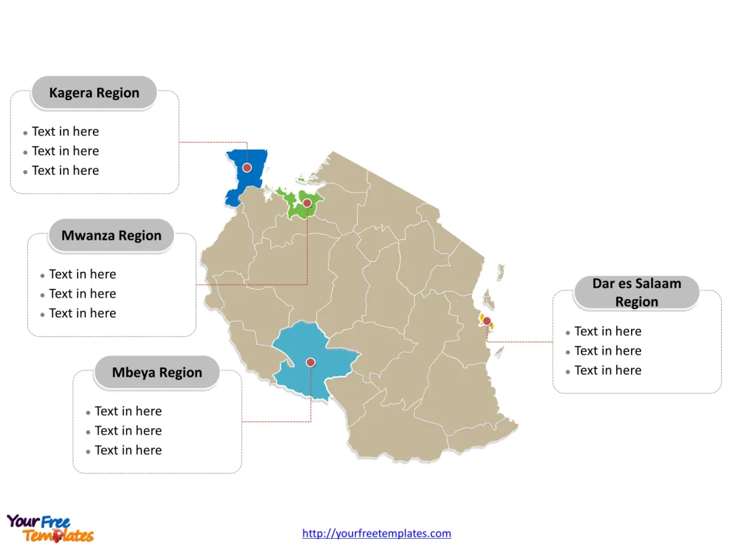
The Tanzania Map Template includes two slides. Tanzania map with 30 regions, labeling major Regions, Dar es Salaam Region, Mwanza Region, Mbeya Region, and Kagera Region. Tanzania map labeled with capital and major cities, Dar es Salaam, Mwanza, Arusha, Dodoma, Mbeya, and Morogoro.
Tanzania, located in East Africa along the Indian Ocean, has a population of approximately 65.6 million people. The country’s economy has shown sustained growth, with a focus on industries such as transportation, infrastructure projects, communications, agriculture, manufacturing, and electricity. Tanzania’s major trading partners include China, India, the European Union, Kenya, South Africa, and the United States.
The nation’s geographic proximity to neighboring countries like Burundi, Democratic Republic of the Congo, Kenya, Malawi, Mozambique, Rwanda, Uganda, and Zambia influences its trade relationships and regional interactions. Tanzania’s diverse geography encompasses Lake Victoria in the west, mountains in the northeast, and coastal plains, contributing to the country’s varied economic activities and natural resources.
Slide 1, Tanzania map labeled with capital and major cities.
Dodoma and Dar es Salaam are the capital and largest city of Tanzania respectively, other major cities including Mwanza, Arusha, Mbeya, and Morogoro.
Capital and major cities on Tanzania map
Dar es Salaam: The Economic Hub
Dar es Salaam, the largest city and commercial capital of Tanzania, is situated on the country’s eastern coast. With a population of over 4.3 million, the city serves as a vital economic and cultural center, offering a blend of urban developments and historical landmarks.
Mwanza: The Port City
Mwanza, Tanzania’s second-largest city, is located on the southern shores of Lake Victoria. With a population of over 700,000, Mwanza is renowned for its economic significance and bustling port, contributing to the country’s trade and commerce.

Arusha: The Gateway to the North
Arusha, situated in the northern part of Tanzania, serves as a gateway to the country’s renowned national parks, including the Serengeti and Kilimanjaro. The city’s population of over 400,000 and its cultural vibrancy make it a significant hub for tourism and commerce.
Dodoma: The Political Center
Dodoma, the capital city of Tanzania, is located in the central part of the country. With a population of over 210,000, Dodoma serves as the political and administrative capital, hosting the National Assembly and contributing to the country’s governance and development.
Mbeya: A City of Commerce and Culture
Mbeya, situated in the southern highlands of Tanzania, is known for its economic significance and cultural heritage. The city’s population of over 385,000 and its strategic location make it an important center for trade and regional interactions.
Morogoro: A Hub of Agriculture and Education
Morogoro, located in the eastern part of Tanzania, is celebrated for its agricultural activities and educational institutions. With a population of over 315,000, Morogoro’s agricultural significance and educational infrastructure contribute to the country’s economic and intellectual landscape
Slide 2, Tanzania map labeled with major administration districts.
Tanzania is a country divided into 30 regions: Arusha Region, Dar es Salaam Region, Dodoma Region, Geita Region, Iringa Region, Kagera Region, Katavi Region, Kigoma Region, Kilimanjaro Region, Lindi Region, Manyara Region, Mara Region, Mbeya Region, Morogoro Region, Mtwara Region, Mwanza Region, Njombe Region, Pemba North Region, Pemba South Region, Pwani Region, Rukwa Region, Ruvuma Region, Shinyanga Region, Simiyu Region, Singida Region, Songwe Region, Tabora Region, Tanga Region, Zanzibar North Region, Zanzibar South Region, and Zanzibar Urban West Region. Every individual political subdivision is an editable shape.
Major regions on Tanzania map
The Dar es Salaam Region encompasses the capital city and serves as a significant administrative, economic, and cultural hub, playing a pivotal role in shaping Tanzania’s national identity and development.

The Mwanza Region, with Mwanza as its largest city, offers a blend of economic vibrancy and natural beauty, contributing to the region’s significance within Tanzania’s landscape.
The Mbeya Region covers the city of Mbeya and its surrounding areas, playing a vital role in Tanzania’s economy as a prominent center for trade, commerce, and agriculture.
The Kagera Region, with Bukoba as a notable city, is known for its cultural richness and natural splendor, contributing to the region’s unique identity and development.
Tanzania’s capital, major cities, and significant regions collectively contribute to the country’s cultural, historical, and economic landscape, making it a captivating destination for visitors and a dynamic hub for residents.
Looking for Premium maps, please visit our affiliate site: https://editablemaps.com/ or https://ofomaps.com/
Size: 141K
Type: PPTX
Aspect Ratio: Standard 4:3
Click the blue button to download it.
Download the 4:3 Template
Aspect Ratio: Widescreen 16:9
Click the green button to download it.
Download the 16:9 Template


