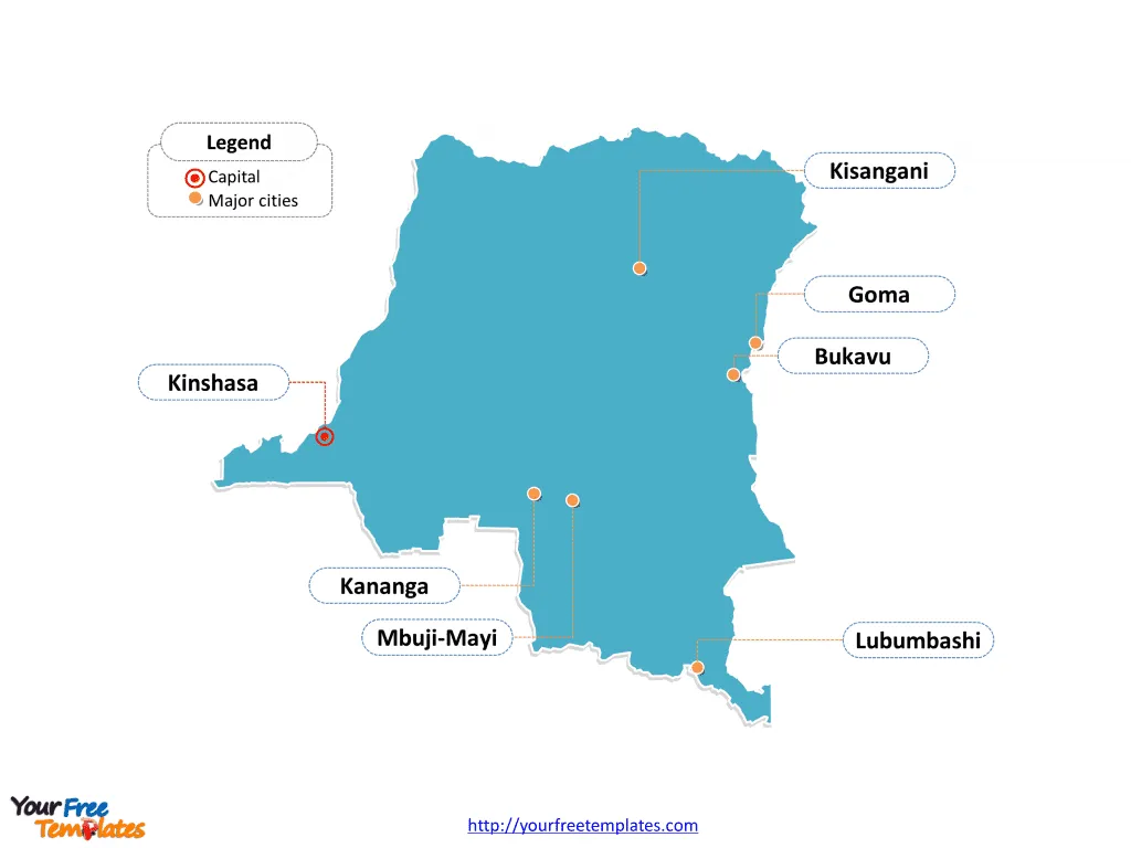
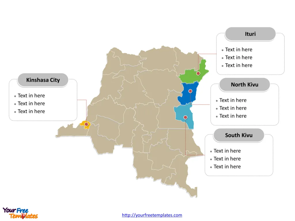
Democratic Republic of Congo Map Template includes three slides. Congo map with 26 provinces, labeling major provinces, Kinshasa, Nord-Kivu, Sud-Kivu, and Ituri. Congo map labeled with capital and major cities, Kinshasa, Lubumbashi, Mbuji-Mayi, Kananga, Kisangani, and Goma.
Location: The Democratic Republic of the Congo (DRC) is located in central Africa and is the largest country in Sub-Saharan Africa, with a 25-mile coastline on the Atlantic Ocean. It shares borders with several countries, including the Republic of the Congo, Central African Republic, South Sudan, Uganda, Rwanda, Burundi, Tanzania, Zambia, Angola, and the Atlantic Ocean to the west.
Population: The estimated population of the DRC in 2024 is approximately 115 million. The country is sparsely inhabited, with a majority of the population residing in cities, particularly in the capital, Kinshasa.
Economy: The DRC is endowed with exceptional natural resources, including minerals such as cobalt and copper, hydropower potential, significant arable land, immense biodiversity, and the world’s second-largest rainforest. However, the country is among the five poorest nations in the world, with an estimated 74.6% of the population living on less than $2.15 a day in 2023.
The real GDP growth remained robust at 7.8% in 2023, driven by a strong mining sector, which contributed around 70% to the overall growth. The agricultural production slowed to 2.2% growth in 2023. The economy’s vulnerability to climate change-related risks is substantial, and the country faces significant challenges related to poverty, nutrition, and access to education.
Neighboring Countries: The DRC shares its borders with several countries, including the Republic of the Congo, Central African Republic, South Sudan, Uganda, Rwanda, Burundi, Tanzania, Zambia, and Angola.
Slide 1, Democratic Republic of Congo Map labeled with capital and major cities.
Kinshasa is the capital and largest city of Congo, other major cities including Lubumbashi, Mbuji-Mayi, Kananga, Kisangani, and Goma.

Democratic Republic of Congo: Capital, Major Cities, and Provinces
Capital and Major Cities:
- Kinshasa: The capital, located on the Congo River, is the largest city in the DRC and serves as the country’s official administrative, economic, and cultural center.
- Lubumbashi: This city, located in the southeastern part of the country, is a major industrial and commercial center.
- Mbuji-Mayi: Known for its diamond mining industry, Mbuji-Mayi is an important city in the DRC.
- Kananga: Situated in the central part of the country, Kananga is a significant urban center.
- Kisangani: Located in the northeastern region, Kisangani is a major city on the Congo River.
- Goma: Situated in the eastern part of the country, Goma is known for its location on the northern shore of Lake Kivu and its proximity to the Rwandan border1.
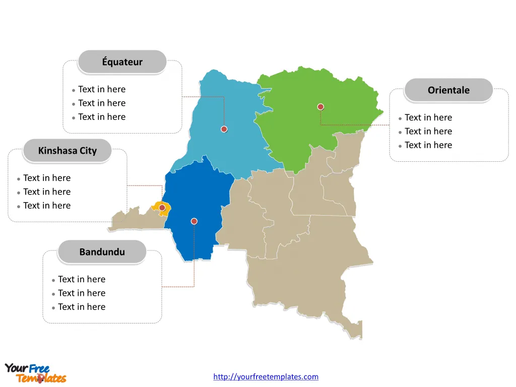
Slide 2, Democratic Republic of Congo Map map with 11 provinces.
Congo is a country divided into 11 provinces before 2016: they are Bandundu, Bas-Congo, Équateur, Kasaï-Occidental, Kasaï-Oriental, Katanga, Kinshasa City, Maniema, Nord-Kivu, Orientale, and Sud-Kivu. Every individual political subdivision is an editable shape.

Slide 3, Democratic Republic of Congo Map with 26 provinces.
Congo is a country divided into 26 provinces in 2016: they are Bas-Uélé, Équateur, Haut-Katanga, Haut-Lomami, Haut-Uélé, Ituri, Kasaï, Kasaï-Central, Kasaï Oriental, Kinshasa, Kongo Central, Kwango, Kwilu, Lomami, Lualaba, Mai-Ndombe, Maniema, Mongala, Nord-Kivu, Nord-Ubangi, Sankuru, Sud-Kivu, Sud-Ubangi, Tanganyika, and Tshopo. Every individual political subdivision is an editable shape.
Major Provinces:
- Kinshasa: The capital city and an administrative province, Kinshasa is a key region in the country.
- Nord-Kivu: Located in the eastern part of the country, Nord-Kivu is known for its scenic landscapes and ongoing security challenges.
- Sud-Kivu: This province in the eastern region is characterized by its natural beauty and challenges related to armed conflict and displacement.
- Ituri: Situated in the northeastern part of the country, Ituri has faced significant humanitarian and security challenges, including intercommunal conflicts and violence1.

The DRC, with its diverse cities and provinces, reflects a complex blend of natural resources, cultural diversity, and persistent economic and social challenges. These regions play a crucial role in shaping the nation’s future and are integral to its growth and progress.
Looking for Premium maps, please visit our affiliate site: https://editablemaps.com/ or https://ofomaps.com/
Size: 108K
Type: PPTX
Aspect Ratio: Standard 4:3
Click the blue button to download it.
Download the 4:3 Template
Aspect Ratio: Widescreen 16:9
Click the green button to download it.
Download the 16:9 Template


