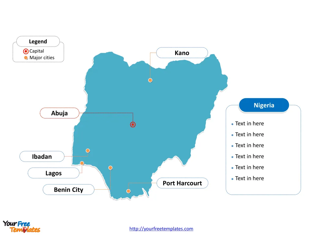
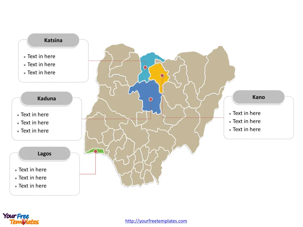
The Nigeria Map Template includes two slides. First Nigeria map with thirty-six states, highlighting Kaduna, Kano, Katsina, and Lagos states. Next Nigeria map labeled with Abuja, Lagos, Kano, Ibadan, Benin City, and Port Harcourt cities.
Nigeria is located in West Africa, lying entirely within the tropical latitudes. It is bordered by Benin to the west, Niger to the north, Chad to the northeast, and Cameroon to the east and southeast. To the south, Nigeria has a coastline along the Gulf of Guinea in the Atlantic Ocean. This strategic location endows Nigeria with a diverse ecological landscape, ranging from lush rainforests in the south to arid plains and savannahs in the north.
As Africa’s most populous country and one of its largest economies, Nigeria plays a crucial role in both regional and continental affairs, acting as a significant cultural, economic, and political hub. It has a population of approximately 182,202,000.
Slide 1, Nigeria map labeled with capital and major cities.
Nigeria, a country of vibrant culture, diverse ecosystems, and rich history, is also distinguished by its dynamic cities and states. Each city and state brings its unique flavor to the tapestry of Nigerian society, contributing to the country’s status as a major economic and cultural powerhouse in Africa. This exploration delves into the major cities of Abuja, Lagos, Kano, Ibadan, Benin City, and Port Harcourt, alongside an overview of the major states of Kaduna, Kano, Katsina, and Lagos.
Major Cities on Nigeria map
Abuja, the capital city of Nigeria, is located in the heart of the country. It was chosen as the capital in 1991 due to its central location, making it more accessible to all Nigerians. Known for its magnificent Aso Rock, a 400-meter monolith, Abuja stands out for its well-planned layout, beautiful parks, and broad avenues. It houses the Nigerian government and is a symbol of Nigeria’s unity and strength.
Lagos, formerly the capital of Nigeria, is now the country’s commercial capital and one of Africa’s largest and fastest-growing cities. It is a city of striking contrasts, where opulent wealth and extreme poverty live side by side. Lagos is renowned for its vibrant arts scene, bustling markets, and lively nightlife. Its Victoria Island and Lekki Peninsula are hubs for business and entertainment, making it a pivotal city for Nigeria’s economic activities.

Kano, located in the northwestern part of Nigeria, is the capital of Kano State and historically a major commercial and cultural center. Its famous ancient Kano City Walls tell tales of a rich history dating back to the 7th century. Kano remains an important Nigerian city for commerce, especially for agricultural produce and textiles, reflecting the city’s enduring legacy as a center for trade routes across the Sahara.
Ibadan, the capital city of Oyo State, is one of Nigeria’s most populous cities and an important cultural center. Known for its sprawling size, Ibadan houses the University of Ibadan, the first university in Nigeria, and several research institutes. The city is a crucial hub for trade and is surrounded by rich agricultural land, making it a significant center for commerce in southwestern Nigeria.
Benin City, located in Edo State, is known for its rich history and cultural heritage, most notably the Benin Bronzes. These artifacts tell the story of the Kingdom of Benin and its advanced artistic achievements. The city is also an important industrial center in southern Nigeria, with a focus on rubber production and processing.
Port Harcourt is the capital of Rivers State and lies along the Bonny River in the Niger Delta. It is Nigeria’s oil and gas hub, home to major multinational corporations and the Port Harcourt Refinery. Despite its industrial significance, the city also offers cultural attractions, including the Port Harcourt Literary Festival, which attracts writers and literature enthusiasts from across Africa.
Slide 2, Nigeria map labeled with major states.
Nigeria is a country divided into thirty-six states and one Federal Capital Territory, Abia, Adamawa, Akwa Ibom, Anambra, Bauchi, Bayelsa, Benue, Borno, Cross River, Delta, Ebonyi, Edo, Ekiti, Enugu, Gombe, Imo, Jigawa, Kaduna, Kano, Katsina, Kebbi, Kogi, Kwara, Lagos, Nasarawa, Niger, Ogun, Ondo, Osun, Oyo, Plateau, Rivers, Sokoto, Taraba, Yobe, Zamfara, and Federal Capital Territory.
Major States on our Nigeria map
Kaduna State, located in the northwestern part of Nigeria, is known for its agricultural prowess, particularly in the production of groundnuts, cotton, and ginger. Its capital, also named Kaduna, is an important industrial center, with textile manufacturing playing a significant role in the local economy.
Kano State is not only significant for housing Kano city but also for being a major agricultural state in Nigeria. It is a leading producer of hides and skins, groundnuts, and cotton. The state plays a vital role in Nigeria’s economy, both historically and presently, as a center for commerce and industry.

Katsina State, located in the northern region of Nigeria, borders Niger Republic. It is primarily an agricultural state, with crops such as millet, sorghum, and cowpeas. Katsina city, the state capital, is an ancient historical town known for its leather crafts and dyeing industries.
Lagos State is arguably the most economically significant state in Nigeria, contributing a significant portion of the country’s GDP. It is a major financial center and has one of the largest and busiest ports on the continent. Lagos State is a melting pot of cultures from across Nigeria and beyond, reflecting a diverse and dynamic society.
Conclusion
Nigeria’s major cities and states are essential in understanding the country’s complex identity. From Abuja’s governmental significance to Lagos’s economic powerhouse, Kano’s historical richness, Ibadan’s educational center, Benin City’s cultural heritage, and Port Harcourt’s industrial importance, these cities showcase Nigeria’s diversity and potential. Similarly, the states of Kaduna, Kano, Katsina, and Lagos each contribute uniquely to Nigeria’s agricultural, industrial, and economic landscape, highlighting the nation’s rich resources and vibrant culture.
Detailed Nigeria Editable map of political administrative divisions please refer to Wikipedia Nigeria.
Size: 141K
Type: PPTX
Aspect Ratio: Standard 4:3
Click the blue button to download it.
Download the 4:3 Template
Aspect Ratio: Widescreen 16:9
Click the green button to download it.
Download the 16:9 Template


