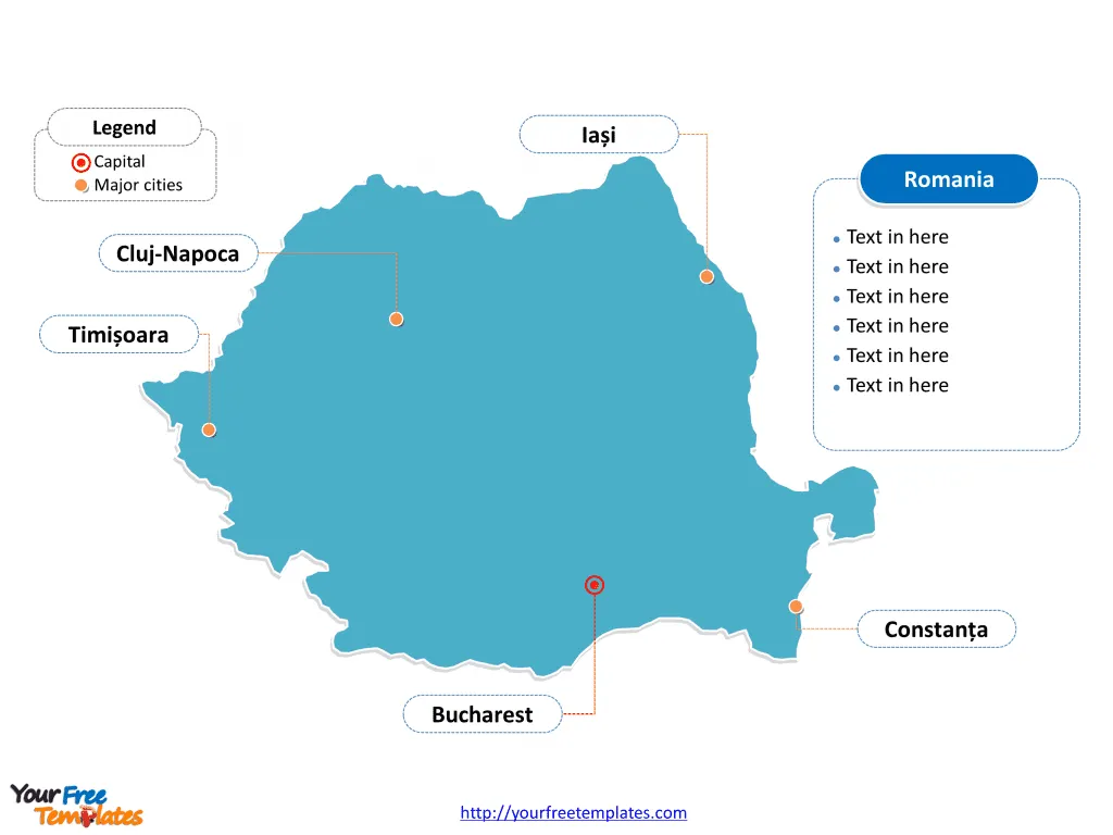
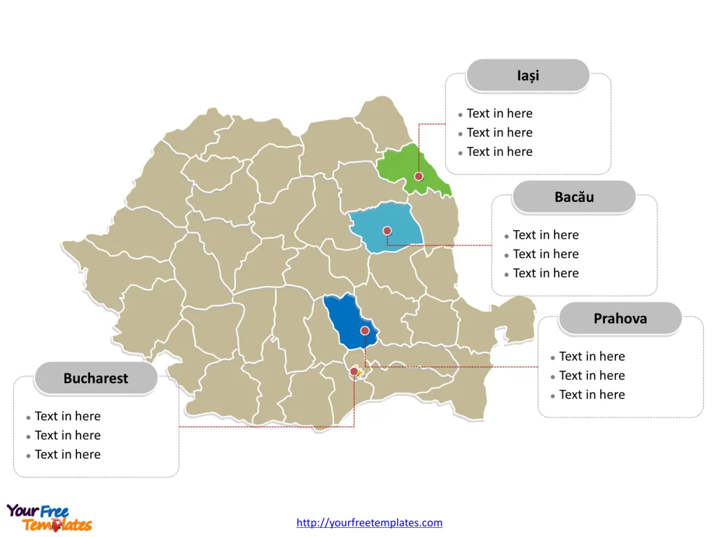
The Romania Map Template includes two slides. Romania map with 41 counties and one city, highlighting Bucharest, Iași County, Prahova County, and Bacău County. The Romania map labeled with Bucharest, Cluj-Napoca, Timișoara, Iași, and Constanța cities.
Romania is located in Southeastern Europe, nestled within the Balkan Peninsula, and is distinguished by its geographical diversity, ranging from mountains, hills, and plains. It lies approximately between latitudes 43°N and 49°N, and longitudes 20°E and 30°E.
Romania shares its borders with five countries: Ukraine to the north, Moldova to the northeast, Bulgaria to the south, Serbia to the southwest, and Hungary to the west. Additionally, Romania has a significant stretch of coastline along the Black Sea to the southeast, which plays a crucial role in its economic, cultural, and social development.
Slide 1, Romania map labeled with capital and major cities.
Romania, a country characterized by its diverse landscapes, rich history, and vibrant cultural tapestry, boasts several major cities and counties that play a pivotal role in its economic, cultural, and administrative framework. Among these, Bucharest, Cluj-Napoca, Timișoara, Iași, and Constanța stand out as key urban centers, while Bucharest Municipality, Iași County, Prahova County, and Bacău County are significant at the county level for their economic contributions and cultural heritage.
Major Cities on Romania map
Bucharest As Romania’s capital and largest city, Bucharest is the heart of the country’s cultural, administrative, and economic activities. With a population of over 1.7 million in 2021, Bucharest is a dynamic urban center known for its wide avenues, the grandiose Parliament Palace (one of the largest buildings in the world), and vibrant nightlife. The city’s architecture, a mix of historical (neo-classical), interbellum (Bauhaus and art deco), communist era, and modern designs, reflects its diverse history and the rapid development it has undergone.

Cluj-Napoca Cluj-Napoca, the seat of Cluj County, is a major educational, cultural, and business hub in Romania. With a population of 286,598 in 2021, it is renowned for its vibrant arts scene, historical landmarks such as St. Michael’s Church, and the Central Park. Cluj-Napoca is also a cornerstone of the Romanian IT industry and hosts numerous festivals and cultural events, contributing to its reputation as a “Silicon Valley” of Eastern Europe.
Timișoara Timișoara, located in the western part of Romania, is known for its multicultural heritage and was the first European city to introduce horse-drawn trams and electric street lighting. With a population of 250,849 in 2021, it is a candidate city for the European Capital of Culture 2023. The city’s numerous parks, historical squares, and active arts scene make it an important cultural and economic center.
Iași Iași, the cultural capital of Moldavia and an important historical city, has a population of 271,692 in 2021. It is home to the oldest Romanian university and numerous cultural institutions, including the Moldova State Philharmonic and the National Theatre. Iași’s rich architectural and historical heritage, exemplified by the Palace of Culture and the Metropolitan Cathedral, make it a key center for Romanian intellectual life and Orthodox spirituality.
Constanța Constanța, Romania’s primary seaport and a major economic hub, has a population of 263,688 in 2021. Its history, dating back over 2,600 years, is visible in its ancient ruins, museums, and the historic Casino, a stunning example of Art Nouveau architecture. Constanța’s beaches and resorts along the Black Sea coast, such as Mamaia, attract numerous tourists annually.
Slide 2, Romania map labeled with major administration districts.
Romania map shows the country divided into 41 counties and one city, Alba, Arad, Argeș, Bacău, Bihor, Bistrița-Năsăud, Botoșani, Brăila, Brașov, Buzău, Călărași, Caraș-Severin, Cluj, Constanța, Covasna, Dâmbovița, Dolj, Galați, Giurgiu, Gorj, Harghita, Hunedoara, Ialomița, Iași, Ilfov, Maramureș, Mehedinți, Mureș, Neamț, Olt, Prahova, Sălaj, Satu Mare, Sibiu, Suceava, Teleorman, Timiș, Tulcea, Vâlcea, Vaslui, Vrancea, and Bucharest. Every individual political subdivision is an editable shape.
Major Counties on Romania map
Bucharest Municipality Bucharest Municipality, encompassing the capital city, is the most significant administrative, economic, and cultural center in Romania. It plays a crucial role in the national economy, with the highest GDP per capita in the country.

Iași County Located in the northeastern part of Romania, Iași County is a major educational and cultural hub, with Iași city as its capital. The county is known for its historical monuments, religious architecture, and vibrant cultural life.
Prahova County Prahova County, situated in the southern part of Romania, is key to the country’s oil industry, with a long history of petroleum extraction and processing. Its capital, Ploiești, and the surrounding mountain resorts, such as Sinaia and Predeal, make it an important economic and tourist region.
Bacău County Bacău County, in the historical region of Moldavia, combines industrial activity with rich cultural traditions. The county’s capital, Bacău, serves as an important industrial center, while the rural areas preserve traditional Romanian crafts and customs.
In conclusion, Romania’s major cities and counties are integral to its identity, offering a blend of historical heritage, cultural richness, and economic vitality. From the bustling streets of Bucharest to the cultural heartland of Iași, each region contributes uniquely to the tapestry that is Romania.
Please check our premium maps in ofomaps.com.
Size: 116K
Type: PPTX
Aspect Ratio: Standard 4:3
Click the blue button to download it.
Download the 4:3 Template
Aspect Ratio: Widescreen 16:9
Click the green button to download it.
Download the 16:9 Template


