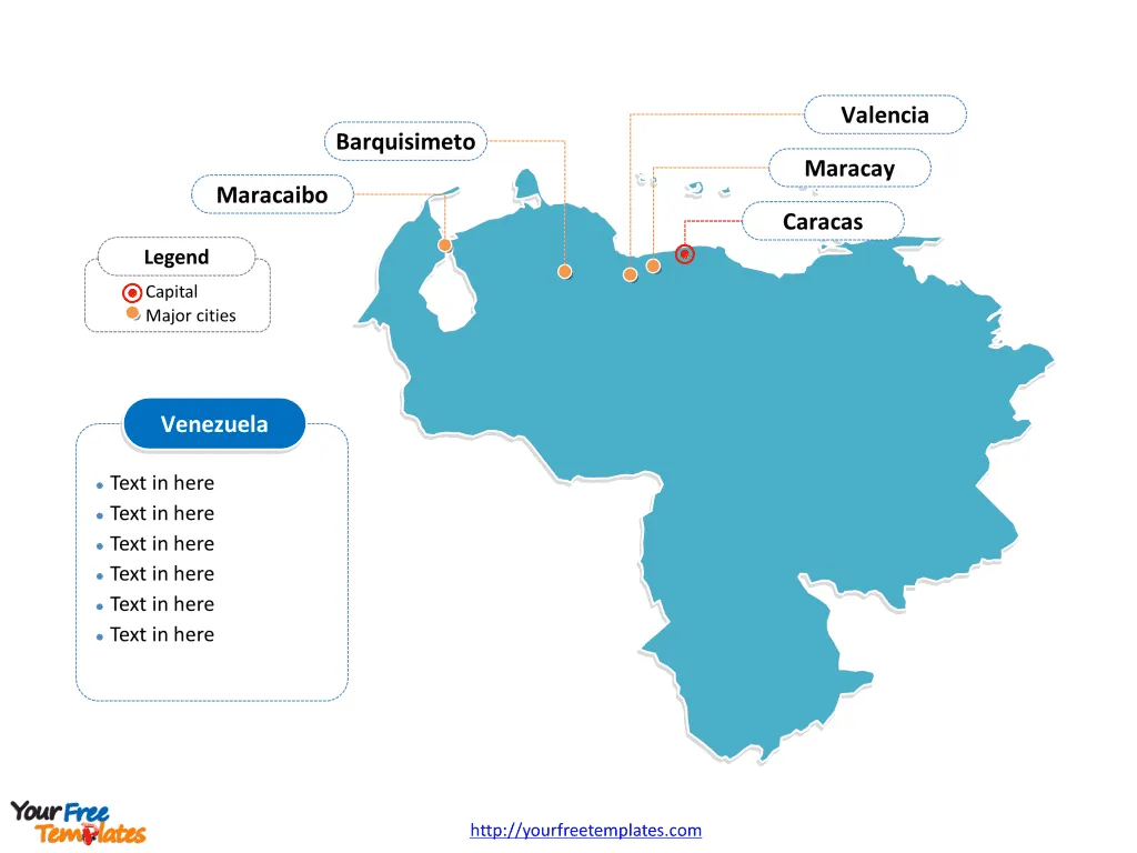
The Venezuela Map Template includes two slides. Venezuela map with twenty-three states, a Capital District and the Federal Dependencies, labeling with major states, Zulia, Miranda, Carabobo, and Lara. Venezuela map labeling with national capital and major cities, Caracas, Maracaibo, Valencia, Barquisimeto, and Maracay.
Location Venezuela is located on the northern coast of South America, bordered by the Caribbean Sea and the North Atlantic Ocean to the north. It shares land borders with Brazil to the south and Colombia to the west. Its proximity to the Caribbean gives it strategic importance in regional trade and geopolitics.
Population As of the latest available data, Venezuela’s population is estimated to be around 28 million people. The country has a diverse demographic makeup, with a rich blend of indigenous, European, and African ancestry contributing to its cultural heritage.
Economy Venezuela’s economy has historically been heavily reliant on its vast oil reserves, which have been a major driver of its economic activity. However, the country has faced significant economic challenges in recent years, including hyperinflation, declining oil production, and political instability. These factors have led to widespread socio-economic difficulties for its population.
Neighboring Countries Venezuela shares its borders with Colombia to the west and Brazil to the south. These neighboring countries influence Venezuela’s trade, migration patterns, and regional dynamics, impacting its economic and geopolitical landscape.
Slide 1, Venezuela map labeled with capital and major cities.
Its capital and largest city is Caracas, other major cities including Maracaibo, Valencia, Barquisimeto, and Maracay.
Capital and Major Cities on Venezuela map
Caracas Caracas, the capital and largest city of Venezuela, is a bustling metropolis nestled in a valley in the northern part of the country. It serves as the political, cultural, and economic center, featuring iconic landmarks such as the Avila National Park and the birthplace of Simón Bolívar. Caracas is a vibrant city with a mix of modern architecture and historical sites, and it plays a pivotal role in Venezuela’s governance and commerce.

Maracaibo Maracaibo, located in the Zulia state, is Venezuela’s second-largest city and a key center for the country’s oil industry. Situated near the shores of Lake Maracaibo, it is a major hub for trade and commerce, contributing significantly to Venezuela’s energy sector.
Valencia Valencia, in the Carabobo state, is an important industrial and manufacturing city. It is known for its diverse economic activities, including automotive and food processing industries, and is a vital transportation and trade hub in central Venezuela.
Barquisimeto Barquisimeto, situated in the state of Lara, is a major cultural and commercial center. It is renowned for its rich musical heritage and vibrant arts scene, making it a dynamic city in western Venezuela.
Maracay Maracay, located in the state of Aragua, is an important city with a strong focus on agriculture and industry. It is known for its pleasant climate and serves as a significant center for military and air force operations.
Slide 2, Venezuela map labeled with major administration districts.
Venezuela is a country with twenty-three states, a Capital District and the Federal Dependencies; they are Amazonas, Anzoátegui, Apure, Aragua, Barinas, Bolívar, Carabobo, Cojedes, Delta Amacuro, Falcón, Guárico, Lara, Mérida, Miranda, Monagas, Nueva Esparta, Portuguesa, Sucre, Táchira, Trujillo, Vargas, Yaracuy, Zulia, Capital District, and Federal Dependencies. Every individual political subdivision is an editable shape.
Major States on Venezuela map
Zulia Zulia is a key state in Venezuela, known for its abundant oil reserves and significant contribution to the country’s oil industry. Maracaibo, the state’s largest city, plays a pivotal role in Zulia’s economic landscape.
Miranda Miranda is an important state that surrounds the capital city of Caracas. It is a region of great cultural and historical significance, with a diverse economy and a mix of urban and rural communities.

Carabobo Carabobo, with Valencia as its major city, is an industrial powerhouse, known for its manufacturing activities and economic contributions. The state’s strategic location and transportation infrastructure make it a vital region for trade and commerce.
Lara Lara is a state with a strong agricultural and industrial focus. Barquisimeto, its largest city, serves as a cultural and commercial hub, contributing to Lara’s economic and social vitality.
In conclusion, Venezuela’s capital, major cities, and states represent the country’s diverse cultural, economic, and geographic characteristics. From the political center of Caracas to the industrial prowess of Maracaibo and Valencia, each location plays a distinct role in shaping Venezuela’s identity and regional dynamics.
Looking for Premium maps, please visit our affiliate site: https://editablemaps.com/ or https://ofomaps.com/
Size: 144K
Type: PPTX
Aspect Ratio: Standard 4:3
Click the blue button to download it.
Download the 4:3 Template
Aspect Ratio: Widescreen 16:9
Click the green button to download it.
Download the 16:9 Template


