

Looking for a Frankfurt city map for a presentation, report, classroom project, business analysis, or geographic research?
Frankfurt am Main is one of Germany’s largest cities and the financial center of the country. But a useful Frankfurt map can show much more than the city outline.
Frankfurt has several different geographic subdivision systems, including 16 Ortsbezirke, 46 Stadtteile, and 121 Stadtbezirke, as well as specialized areas for police, courts, civil registration, and conciliation services.
In this collection, we provide several free Frankfurt map resources and explain what each type of map can be used for.
Frankfurt on the Map of Germany
Frankfurt am Main is located in the German state of Hesse (Hessen) in central-western Germany.
The city lies on the River Main and is one of Europe’s major transportation and financial centers.
Frankfurt is particularly well known for:
- European financial services
- Frankfurt Airport
- Messe Frankfurt
- the European Central Bank
- its major railway station
- international business and trade fairs
A Germany map showing Hesse provides useful geographic context before looking at Frankfurt’s internal districts.
Frankfurt’s Location in Hesse
The first map in this collection shows the location of Frankfurt am Main within Hesse and Germany.
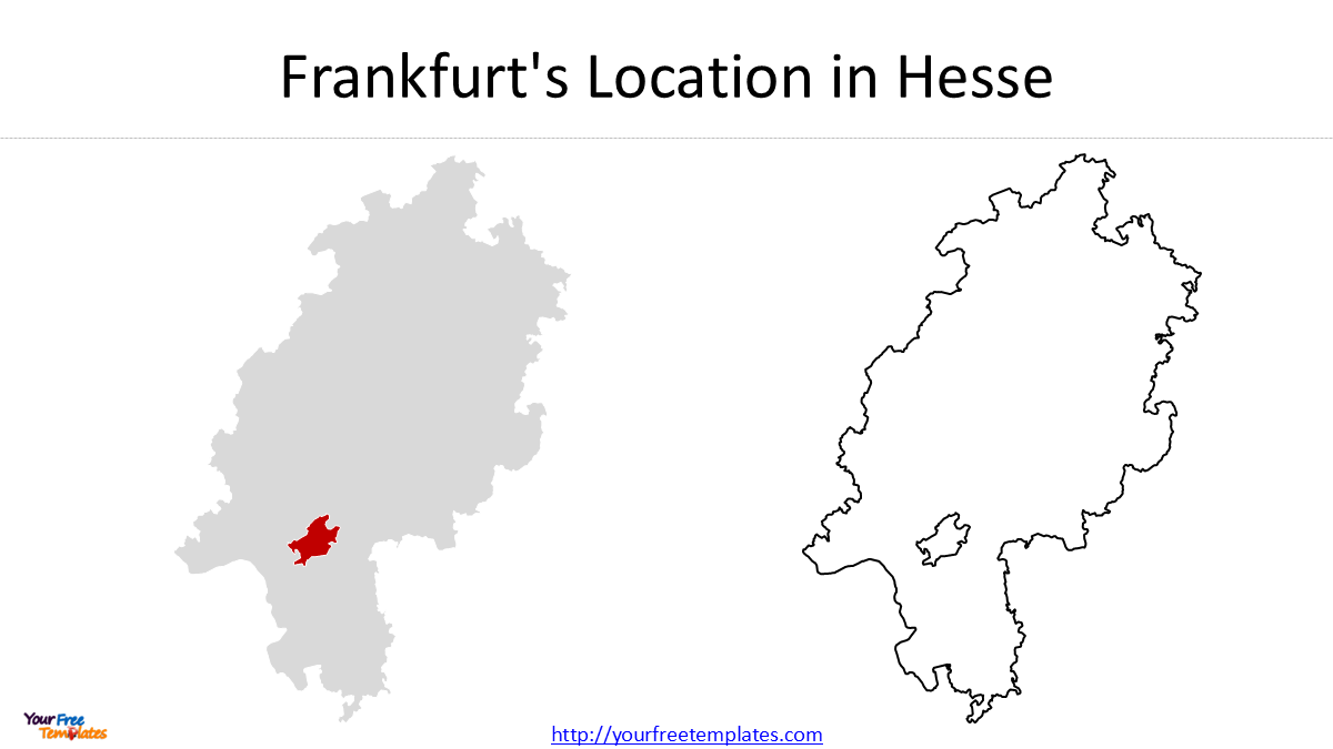
This type of map is useful for:
- presentations
- geography education
- business reports
- travel planning
- regional analysis
Free Frankfurt City Outline Map
The simplest Frankfurt map is the city outline.
It shows the external boundary of Frankfurt am Main without displaying the internal administrative subdivisions.
This makes it useful as a background map for:
- PowerPoint presentations
- location maps
- business presentations
- infographics
- transportation maps
- tourism materials
The outline is also a useful starting point when you want to add your own data.
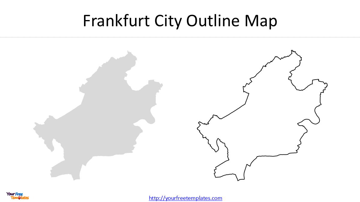
A clean city outline is often more useful in presentations than a highly detailed administrative map because it provides geographic context without overwhelming the audience.
Frankfurt’s 16 Ortsbezirke
Frankfurt is divided into 16 Ortsbezirke, which can be translated as Area Districts.
These are important municipal subdivisions and are associated with local district advisory bodies.
A map of the 16 Ortsbezirke provides a relatively simple way to divide Frankfurt into larger geographic areas. The 16 area districts are Bergen-Enkheim, Bornheim/Ostend, Harheim, Innenstadt I, Innenstadt II, Innenstadt III, Kalbach/Riedberg, Mitte-Nord, Mitte-West, Nieder-Erlenbach, Nieder-Eschbach, Nord-Ost, Nord-West, Ost, Süd, and West.
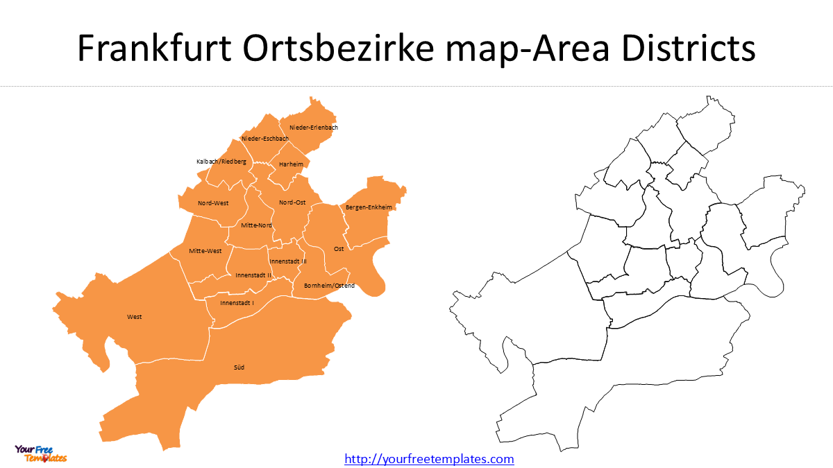
Compared with a map showing more than one hundred small boundaries, a 16-district map is easier to read and works well for:
- city-level presentations
- municipal analysis
- business reports
- regional comparisons
- educational materials
Why Use 16 Ortsbezirke?
If your audience needs to understand Frankfurt’s overall internal structure, the 16 Ortsbezirke provide a good balance between geographic detail and readability.
A presentation can highlight individual districts without creating an overly complicated map.
Other Frankfurt Geographic Divisions
Frankfurt’s GIS system contains several other types of geographic boundaries.
These should not be confused with the normal municipal district structure because they serve different administrative or public-service functions.
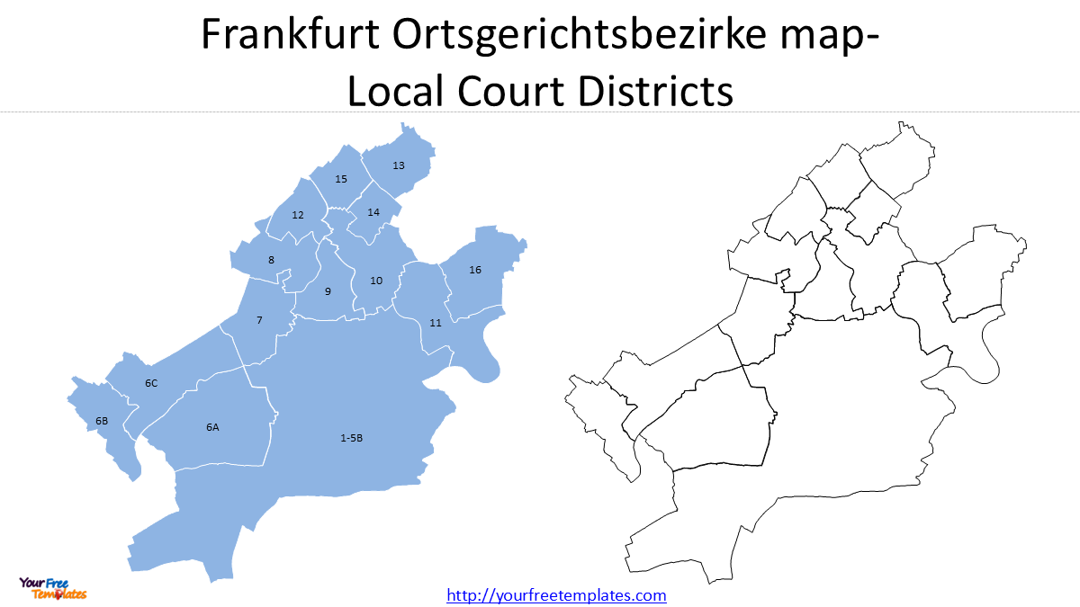
Ortsgerichtsbezirke
Ortsgerichtsbezirke are Local Court Districts.
They represent judicial service areas and should not be confused with Stadtteile or Ortsbezirke. The 14 local court districts numbers are 1-5B, 10, 11, 12, 13, 14, 15, 16, 6A, 6B, 6C, 7, 8, and 9.
Polizeireviere
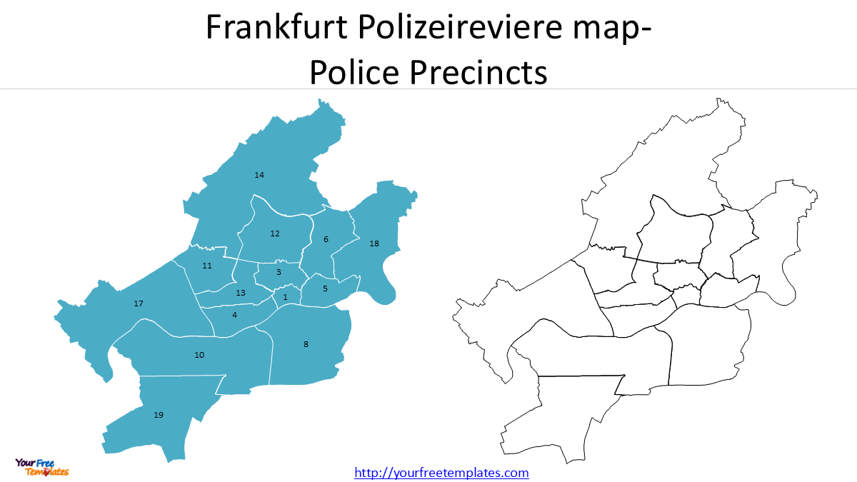
Polizeireviere are Police Precincts.
They represent the geographic areas associated with police organization and service. There are 14 police precincts.
A police precinct map can therefore be useful for studying public-service coverage rather than municipal administration.
Schiedsamtsbezirke
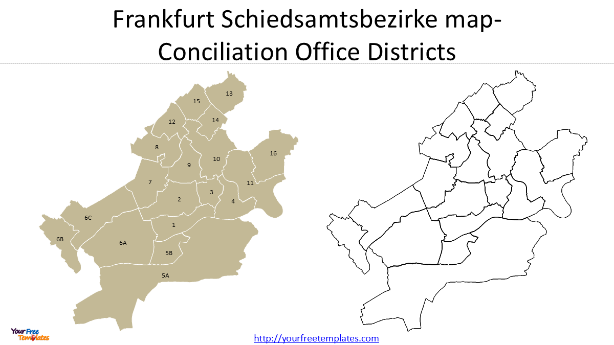
Schiedsamtsbezirke can be translated as Conciliation Office Districts. There are 19 Conciliation Office Districts,which are 1, 2, 3, 4, 7, 8, 9, 10, 11, 12, 13, 14, 15, 16, 5A, 5B, 6A, 6B, 6C.
They represent areas associated with local conciliation services.
Standesamtsbezirke
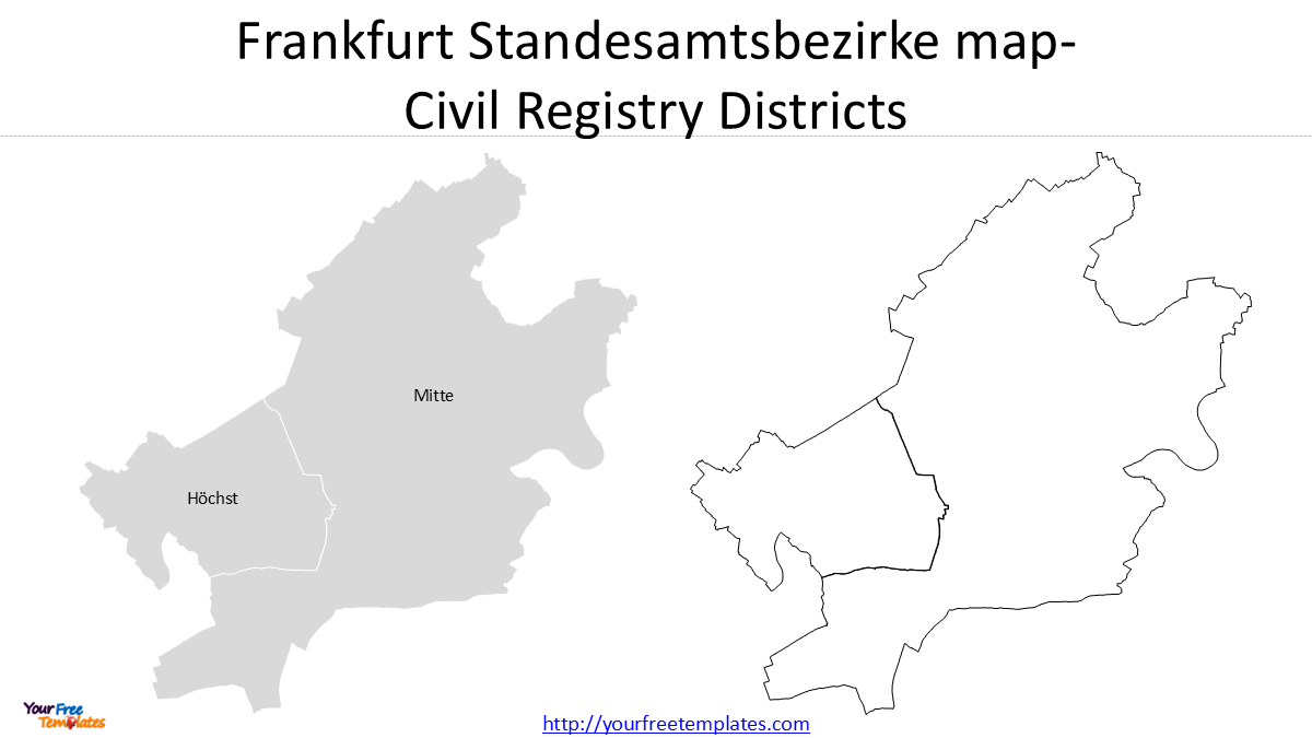
Standesamtsbezirke are Civil Registry Districts. There are two of them, Mitte and Höchst.
They are associated with civil registration services, including matters such as births, marriages, and deaths.
Summary of Frankfurt Map Types
| German | English | Main purpose |
|---|---|---|
| Ortsbezirke | Area Districts | Municipal organization |
| Stadtteile | City Districts | Urban/neighborhood geography |
| Stadtbezirke | City Boroughs | Detailed municipal geography |
| Schiedsamtsbezirke | Conciliation Office Districts | Conciliation services |
| Polizeireviere | Police Precincts | Police services |
| Ortsgerichtsbezirke | Local Court Districts | Judicial services |
| Standesamtsbezirke | Civil Registry Districts | Civil registration |
Information Gain: These boundaries answer different questions. A Stadtteil tells you about Frankfurt’s urban geography, while a Polizeirevier tells you about police service coverage. Using the wrong boundary can lead to a misleading map.
Which Frankfurt Map Should You Choose?
The best map depends on what you want to communicate.
| Your purpose | Recommended map |
|---|---|
| Show Frankfurt’s location | Germany/Hesse location map |
| Simple presentation | Frankfurt city outline |
| Municipal overview | 16 Ortsbezirke |
| Neighborhood analysis | 46 Stadtteile |
| Detailed geographic analysis | 121 Stadtbezirke |
| Police analysis | Polizeireviere |
| Judicial analysis | Ortsgerichtsbezirke |
| Civil registration analysis | Standesamtsbezirke |
For most general presentations, the city outline or 16 Ortsbezirke provides the best balance between clarity and information.
For detailed neighborhood-level work, the 46 Stadtteile provide much more geographic information.
For highly detailed analysis, the 121 Stadtbezirke provide an even finer geographic framework.
Free Frankfurt Map Templates Download
We provide free Frankfurt map resources that can be used for presentations and other projects.
The free collection includes:
- Frankfurt location map
- Frankfurt city outline
- Frankfurt 16 Ortsbezirke map
- selected Frankfurt administrative and service-area maps
These resources are particularly useful when you need a clean geographic base but do not require every small district boundary.
Size:735K
Type: PPTX
Frankfurt city map Template
Click the link to download it.
Aspect Ratio: Widescreen 16:9
Click the green button to download it.
Download the 16:9 Template
Need a More Detailed Frankfurt Map?
If you need a detailed, ready-to-use map of Frankfurt’s 46 Stadtteile or 121 Stadtbezirke, creating the map from raw Frankfurt GIS data can take considerably more time.
You need to:
- obtain the official boundary data;
- select the correct geographic layer;
- clean and simplify the polygons;
- arrange the map;
- add labels;
- prepare the individual districts for editing;
- optimize the map for presentation.
If you need these detailed boundaries in an editable presentation format, you can find the corresponding Frankfurt map products at Editable Maps.
Looking for Premium maps, please visit our affiliate site: https://editablemaps.com/ or https://ofomaps.com/
Explore Frankfurt City Maps with 46 Stadtteile and 121 Stadtbezirke
The detailed products are designed for users who need ready-to-use maps rather than raw GIS data.
Frankfurt Map Data Source
The geographic boundaries used for these maps can be traced back to official Frankfurt geographic information services.
For users who want to work directly with the source data, we have also prepared a separate tutorial:
Frankfurt GIS Data: How to Download WFS and Export Shapefiles with QGIS
That guide explains how to connect to Frankfurt’s WFS, select the required layer, download the geographic features, and export them into GIS formats.
Conclusion
A Frankfurt city map can mean very different things depending on the purpose.
A simple city outline is ideal for location maps and presentations. The 16 Ortsbezirke provide a useful municipal overview, while specialized boundaries such as Schiedsamtsbezirke, Polizeireviere, Ortsgerichtsbezirke, and Standesamtsbezirke provide geographic information for specific public services.
For more detailed urban geography, the 46 Stadtteile and 121 Stadtbezirke provide substantially greater geographic detail.
By choosing the appropriate boundary level, you can make a Frankfurt map both more accurate and more useful—without adding unnecessary complexity.
You may also be interested in our related Germany templates: