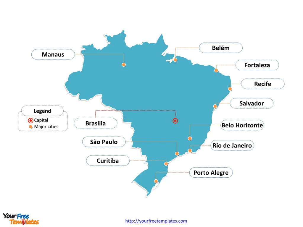
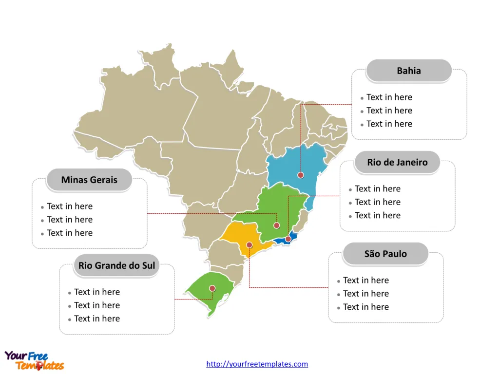
Brazil map with the Federal District, and the 26 states, highlighting Bahia, Minas Gerais, Rio Grande do Sul, Rio de Janeiro, and São Paulo states. Brazil map of outline labeled with Brasília, São Paulo, Rio de Janeiro, Salvador, Fortaleza, Belo Horizonte, Curitiba, Manaus, Recife, Belém, and Porto Alegre cities.
Brazil is a country of immense diversity and natural beauty, stretching across half of South America. It is the fifth-largest country in the world by area covering 8.5 million square kilometres and the sixth-largest by population with a population of 200 million people. Brazil’s strategic geographical location encompasses a variety of landscapes, from the Amazon rainforest to the bustling city streets, and from sun-kissed beaches to the expansive pampas.
The Map of Brazil Template includes two slides.
Slide 1, Brazil map outline labeled with capital and major cities.
Location and Geography
Brazil is bordered by the Atlantic Ocean on the east and shares its northern, western, and southern borders with every South American country except Chile and Ecuador. The neighboring countries are 1.Argentina 2. Bolivia 3. Colombia 4. French Guiana 5. Guyana 6. Paraguay 7. Peru 8. Suriname 9. Uruguay 10. Venezuela. The equator crosses through the north of Brazil, giving it a mix of tropical and subtropical climates. The vast Amazon Basin occupies a substantial part of the country, housing the largest rainforest on Earth.
Its capital and largest city is Brasília and São Paulo respectively, other major cities including Rio de Janeiro, Salvador, Fortaleza, Belo Horizonte, Curitiba, Manaus, Recife, Belém, and Porto Alegre on Brazil map.
Major Cities
- Brasília: The capital city, known for its modernist architecture by Oscar Niemeyer and Lucio Costa’s innovative urban planning. Brasília serves as the Federal District and is the seat of the Brazilian government.
- São Paulo: As the largest city in Brazil, São Paulo is the epicenter of commerce and culture, often referred to as the financial heart of Brazil. It’s a melting pot of nationalities and cultures, making it one of the most diverse cities in the world.
- Rio de Janeiro: World-renowned for its breathtaking landscape, carnival festival, samba music, and iconic landmarks such as the Christ the Redeemer statue and Copacabana Beach. Rio emanates vibrant energy and a zest for life.
- Salvador: The capital of the state of Bahia, Salvador is known for its Portuguese colonial architecture, Afro-Brazilian culture, and a historic center that is a UNESCO World Heritage Site.
- Fortaleza: A major city on Brazil’s northeast coast, known for its beaches and as a gateway to the stunning landscapes of Ceará state.
- Belo Horizonte: The capital of Minas Gerais, known for its array of cultural institutions and the surrounding historic towns with colonial architecture.

Slide 2, Brazil map labeled with major administration districts.
Brazil map shows the country composed of the union of the Federal District, and the 26 states. Every individual political subdivision is an editable shape.
Major States and Federal District
Each state has its own government and a degree of autonomy. Here are some of the most prominent states on the Brazil map:
- São Paulo State: Besides the sprawling metropolis of São Paulo city, the state is economically powerful and agriculturally diverse, known for its sugar cane, coffee, and orange production.
- Minas Gerais: Famous for its colonial-era towns, like Ouro Preto, and significant mining industry.
- Rio de Janeiro State: Apart from the city, the state also boasts beautiful coastal towns, mountain retreats, and the vital offshore oil and gas reserves.
- Bahia: A state with a strong African influence on its culture, cuisine, and religion, Bahia is a center for Brazilian music and folklore.
- Paraná: Home to the stunning Iguaçu Falls on the border with Argentina and important agricultural lands.
- Rio Grande do Sul: Known for its gaucho culture and as Brazil’s wine country, it borders Uruguay and Argentina.
- Santa Catarina: Offers a mix of beautiful beaches and mountainous regions, with a strong European influence in its culture.
Federal District
- Brasília (Federal District): Unlike any other city, Brasília was constructed in the late 1950s and officially became the capital in 1960. The city was designed in the shape of an airplane, symbolizing Brazil’s progress towards the future. It is an administrative division rather than a state, harboring all three branches of the Brazilian government.

The vastness of Brazil is reflected not only in its size but also in the cultural and natural riches it offers. From the economic powerhouses of São Paulo and Rio de Janeiro to the historic gems of Minas Gerais and Bahia, each state adds to the country’s allure. The Federal District’s distinctive design and purpose are emblematic of Brazil’s forward-thinking spirit. Whether drawn by the call of the urban jungle or the tranquility of the Amazon, Brazil provides an endless canvas for exploration and discovery.
Find out more about this country in Simple Wiki.
Size: 104K
Type: PPTX
Aspect Ratio: Standard 4:3
Click the blue button to download it.
Download the 4:3 Template
Aspect Ratio: Widescreen 16:9
Click the green button to download it.
Download the 16:9 Template


